Taupō Volcano
[13] In this region the Moho discontinuity starts about 25–30 km (16–19 mi) beneath the surface beyond the modern Taupō Rift boundaries to the west and east, but there is an area of strong contrast in seismic velocity at 16 kn (30 km/h; 18 mph) depth that is postulated to be due to intruded crust from where the feed magma is evolving.
[13] For unknown as yet reasons, possibly associated with the present high rate of rift spreading and the recent subduction of the Hikurangi Plateau this area is very productive in its surface volcanism.
If the volcano creates a stable plume, high in the atmosphere, the pumice and ash are blown sideways, and eventually fall to the ground, draping the landscape like snow.
If the material thrown out cools more rapidly and becomes denser than the air, it cannot rise as high, and suddenly collapses back to the ground, forming a pyroclastic flow, hitting the surface like water from a waterfall, and spreading sideways across the land at enormous speed.
Some of these were enormous, and two eruptions around 1.25 and 1.0 million years ago were big enough to generate an ignimbrite sheet that covered the North Island from Auckland to Napier.
Most of New Zealand was affected by ashfall, with an 18 cm (7.1 in) ash layer left even on the Chatham Islands, 850 km (530 mi) away which included diatoms from erupted lake sediments.
[20][21] The type of eruption that occurred is the most extreme volcanic hazard due to the pyroclastic flows very high mobility and heat content.
[16]: 129 The eruption went through several stages which were redefined in 2003 with at least 3 separate vents:[16]: 122–124 The main pyroclastic flow devastated the surrounding area, climbing over 1,500 m (4,900 ft) to overtop the nearby Kaimanawa Ranges and Mount Tongariro, and covering the land within 80 ± 10 km (49.7 ± 6.2 mi) with ignimbrite from Rotorua to Waiouru.
[14]: 128–9 The power of the pyroclastic flow was so strong that in some places it eroded more material off the ground surface than it replaced with ignimbrite.
Its new deposits also briefly created another large lake to the Taupō Volcano's north that extended to the Reporoa Caldera which in due course broke out into the Waikato River valley and released over a short period 2.5 km3 (0.60 cu mi) of water.
[26] It is possible that the meteorological phenomena described by Fan Ye in China and by Herodian in Rome[27] were due to this eruption, which would give a date of exactly 186.
[6] New Zealand was unpopulated at that time, so the nearest humans would have been in Australia and New Caledonia, more than 2,000 km (1,200 mi) to the west and northwest.
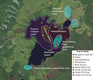
2b Recent activity to the north of the lake is assigned in terms of magma bodies, to the Poihipi volcano under Wairakei.
Discussion From May through December 2022 there was increased earthquake activity with lakeside slumping and inundation from a small tsunami and ground deformation.
The intra-rift Waihi fault, for example, has been associated with 6.5 magnitude earthquakes at recurrence intervals of between 490 and 1,380 years and at least one tsunami related to landslip at the Hipaua steaming cliffs.
While volcanism was recognised in the area following human occupation the recognition of the presence of a large volcano under Lake Taupō was not.
[41]: 1 The resulting report conclusion on the cause of the eruption "I think there can be little question that it is a purely hydro-thermal phenomenon, but on a gigantic scale; that it is quite local and not of deep-seated origin..."[41]: 6 generated controversy with some supporting this view due to their geological understanding of the time.
"[43]: 5 He deferred to others who he was collaborating with, in the same timeframe, and as already mentioned Thomas first crystallised the possibility in the geological literature that there was a volcano under Lake Taupō as the likely source of the extensive surface pumice deposits from field work including analysis of specimens forwarded by Cussen.
[14]: 108 Further understanding of the size of the Hatepe eruption from the Taupō volcano with its pyroclastic flows and vent location resulted from the work of Colin Wilson from 1980 onward.