Rapid intensification
Rapid intensification constitutes a major source of error for tropical cyclone forecasting, and its predictability is commonly cited as a key area for improvement.
Rapid intensification events are typically associated with warm sea surface temperatures and the availability of moist and potentially unstable air.
[4][a] In 2003, John Kaplan of the Hurricane Research Division and Mark DeMaria of the Regional and Mesoscale Meteorology Team at Colorado State University defined rapid intensification as an increase in the maximum one-minute sustained winds of a tropical cyclone of at least 30 knots (55 km/h; 35 mph) in a 24-hour period.
[9] The NHC also defines a similar quantity, rapid deepening, as a decrease in the minimum barometric pressure in a tropical cyclone of at least 42 mbar (1.2 inHg) in 24 hours.
[3] Within the North Atlantic, intensification rates are on average fastest for storms with maximum one-minute sustained wind speeds of 70–80 kn (130–150 km/h; 80–90 mph).
In the South-West Indian Ocean, intensification rates are fastest for storms with maximum ten-minute sustained wind speeds of 65–75 kn (120–140 km/h; 75–85 mph).
Smaller tropical cyclones are more likely to undergo quick intensity changes, including rapid intensification, potentially due to a greater sensitivity to their surrounding environments.
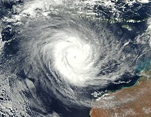
[14] Patricia also holds the record for the largest pressure decrease in 24 hours based on RSMC data, deepening 97 mbar (2.9 inHg).
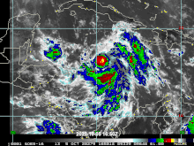
The presence of wind shear concentrates convective available potential energy (CAPE) and helicity and strengthens inflow within the downshear[b] region of the tropical cyclone.
Such conditions are conducive to vigorous rotating convection, which can induce rapid intensification if located close enough to the tropical cyclone's core of high vorticity.
However, wind shear also concurrently produces conditions unfavorable to convection within a tropical cyclone's upshear[b] region by entraining dry air into the storm and inducing subsidence.
These upshear conditions can be brought into the initially favorable downshear regions, becoming deleterious to the tropical cyclone's intensity and forestalling rapid intensification.
[27] Tropical cyclones that undergo rapid intensification in the presence of moderate (5–10 m/s (20–35 km/h; 10–20 mph)) wind shear may exhibit similarly asymmetric convective structures.
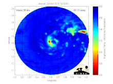
[36][37] In December 2016, the CYGNSS SmallSat constellation was launched with a goal of measure ocean surface wind speeds with sufficiently high temporal resolution to resolve rapid intensification events.
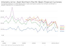
[18] Weather models have also shown an improved ability to project rapid intensification events,[40] but continue to face difficulties in accurately depicting their timing and magnitude.
[45] The first working group report of the IPCC Sixth Assessment Report – published in 2021 – assessed that the global occurrence of rapid intensification likely increased over the preceding four decades (during the period of reliable satellite data), with "medium confidence" in this change exceeding the effect of natural climate variability and thus stemming from anthropogenic climate change.
[51][52] However, CMIP5 climate projections suggest that environmental conditions in by the end of the 21st century may be less favorable for rapid intensification in all tropical cyclone basins outside of the North Indian Ocean.