Mesocyclone
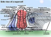
A mesocyclone is a meso-gamma mesoscale (or storm scale) region of rotation (vortex), typically around 2 to 6 mi (3.2 to 9.7 km) in diameter, most often noticed on radar within thunderstorms.
[1] Mesocyclones are medium-scale vortices of rising and converging air that circulate around a vertical axis.
Mesocyclones are identified by Doppler weather radar observations as a rotation signature which meets specific criteria for magnitude, vertical depth, and duration.
[citation needed] They are of greatest concern when contained within severe thunderstorms, since mesocyclones often occur together with updrafts in supercells, within which tornadoes may form near the interchange with a downdraft.
A mesovortex is a similar but typically smaller and weaker rotational feature associated with squall lines.
The gallery below shows the three stages of development of a mesocyclone and a view of the storm relative motion on radar of a mesocyclone-producing tornado over Greensburg, Kansas on 4 May 2007.
[4] Mesocyclones are most often located in the right-rear flank of supercell thunderstorms and when embedded within squall lines (whereas mesovortices most often form in the front flank of squall lines), and may be distinguished by a hook echo rotation signature on a weather radar map.
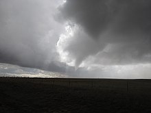
Visual cues such as a rotating wall cloud or tornado may also hint at the presence of a mesocyclone.
This is why the term has entered into wider usage in connection with rotating features in severe storms.
[8] For a tornado to form in this manner, a rear-flank downdraft enters the center of the mesocyclone from the back.