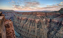
Toroweap Overlook
The term Tuweep, a Paiute word for "the earth", was used for an early Mormon settlement in the valley, and is now used by the National Park Service to refer to the area.
[1] At Toroweap the layer of soft Hermit Shale is about 800 feet thick, much thicker than farther east.
Sediment and lava flows eventually filled the side canyon to the level of the Esplanade Platform.
The Clay Hole road reaches the overlook from Colorado City, 56 miles from Toroweap, however, this route should not be traveled after rain or snow.
The National Park Service only intermittently staffs the Tuweep ranger station 6 miles north of the overlook.
There is a primitive campground 1 mile north of the overlook that now requires reservations several days in advance from the Grand Canyon National Park backcountry office.
This trail starts in Grand Canyon-Parashant National Monument at Whitmore Canyon Overlook, 9 miles west of Toroweap.