Transportation in metropolitan Detroit
[1] The Erie Canal, which had first been proposed in 1807, opened in 1825 and greatly improved access to Detroit and other Michigan ports from Europe and the eastern seaboard.
The Detroit, Toledo and Ironton Railroad was formed in 1905 from the merger of two existing companies; it went bankrupt in 1908 but remained solvent and was later bought by Henry Ford in 1920 to carry raw materials and finished goods to and from his factories in Dearborn, Michigan.
In 1920, mayor James Couzens vetoed a bond issue which would build a subway system, but it failed by one vote.
The years following the Wall Street Crash of 1929 until 1969 saw the creation of the Interstate Highway System, rapid growth of the suburbs and associated shopping malls, the growing importance of civil aviation, and growing dominance of the motorcar; it also witnessed the end of the streetcar system in the city followed by an increased use of buses and the creation of three successful trolleybus lines.
This work was undertaken when Fort Street close to the Ford River Rouge Complex was converted to a "superhighway" with a divided highway and night-time lighting.
Then in 1931, the Grand Trunk Western Railroad launched a commuter service between Detroit and Pontiac, the trip took 45 minutes.
In 1941, the Willow run bypass was rapidly constructed as a four-lane divided highway following the attack on Pearl Harbor to bring workers from Detroit to the Willow Run factory to the west of the city where Henry Ford had constructed a factory to produce the B-24 Liberator military aircraft.
By 1945, plans had been drawn up for a system of expressways and subways which included trains running within the median strips of these roads.
On September 15, 1949, the Crosstown (Warren Avenue) was converted experimentally into trolleybus service from Saint Jean Street to the Pierson Loop, although from 1955 to 1959 it operated to Ann Arbor Trail.
[10] The Saint Lawrence Seaway opened in 1959, allowing ocean-going ships to access the Great Lakes and Detroit.
The new Jeffries Freeway (I-96) was intended to have followed the route of Grand River Avenue; however it led to opposition as did many other schemes across the country.
Also in 1976, president Gerald Ford offered $600 million for a region-wide mass transit system, however, except for the Detroit People Mover, it was never built.
In December 1988, Public Act 204 was amended and SEMTA was reduced to just Macomb, Oakland and Wayne counties, excluded the city of Detroit and renamed the Suburban Mobility Authority for Regional Transportation (SMART).
Another attempt was made in late 1996 when SMART started operating full service in Detroit and DDOT launched five suburban routes, however that too never took off.
[16][17][18] 3.5 miles (5.6 km) of continuous RiverWalk along the Detroit International Riverfront between the Ambassador Bridge and Belle Isle and two of four planned pavilions opened in 2007.
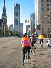
The 'Detroit Non-Motorized Master Plan' was also published which proposed 400 miles (640 km) of bike lanes primarily through road diets.
Located in nearby Romulus, DTW is metro Detroit's principal airport and is a hub for Delta Air Lines and Spirit Airlines.
[21] Willow Run Airport in Ypsilanti primarily serves commercial aviation and offers charter services.
However, as the automotive era began, the interests of bicycle shop owners, manufacturers, racers, and enthusiasts turned to the automobile.
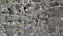
The region's extensive toll-free highway system which, together with its status as a major port city, provide advantages to its location as a global business center.
No substantial rail transit system currently exists in Metro Detroit, so buses constitute the bulk of the area's public transportation network.
The two systems coexist and complement one another's services, with an operating alliance and reciprocal fare agreement managed by the RTA of Southeast Michigan.
In addition, commuter express routes, operating during weekday rush hours, connect suburban park-and-ride lots to downtown.
SMART, on the other hand, uses a wider palette of colors; their newest buses are gray, while others are painted in black, blue-and-yellow, green-and-yellow, and green-and-white schemes.
Throughout the city's recent history, numerous plans to construct bus rapid transit lines have been proposed, though none have yet come to fruition.
[27] The QLine, built in the mid-2010s, is a 3.3-mile (5.3 km) electric streetcar which runs from downtown Detroit to Midtown and New Center, following Woodward Avenue for its entire length, and stopping at twelve stations.
It connects downtown with Little Caesars Arena, Wayne State University, numerous museums, and the city's Amtrak station.
The Wolverine makes intermediate stops in Troy, Royal Oak, Midtown Detroit, Dearborn, and Ann Arbor, before continuing west through Michigan and Indiana to its terminus at Chicago Union Station.
Indian Trails is among the largest, operating services from Detroit to Ann Arbor, Flint, Lansing, Grand Rapids, Kalamazoo, St. Ignace, and Chicago, among other destinations.
[33] Most intercity buses in Detroit originate at the city's main bus terminal, an MDOT-owned facility located on Howard Street just southwest of downtown.