Tropical Storm Andrea (2013)
Tropical Storm Andrea brought flooding to Cuba, the Yucatan Peninsula, and portions of the East Coast of the United States in June 2013.
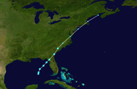
The first tropical cyclone and named storm of the annual hurricane season, Andrea originated from an area of low pressure in the eastern Gulf of Mexico on June 5.
Despite strong wind shear and an abundance of dry air, the storm strengthened while initially heading north-northeastward.
Prior to becoming a tropical cyclone, the precursor to Andrea dropped nearly 12 inches (300 mm) of rainfall on the Yucatán Peninsula.
After Andrea transition into an extratropical storm, the remnants that also spawned one tornado in North Carolina, though damage was minor.
The remnants of Andrea also brought gusty winds to Atlantic Canada, causing thousands of power outages in Nova Scotia and New Brunswick.
As a tropical wave approached from the east, an inverted trough developed on the northern edge of the active region on June 2, setting the stage for the formation of a weak surface low pressure system over the southern Gulf of Mexico the next day.
[3] A nearby upper trough created unfavorable conditions for tropical cyclogenesis, subjecting the low to wind shear and abundant dry air that kept it indistinct and disorganized.
In response, the NHC initiated advisories on Tropical Storm Andrea later that day,[4] while centered about 310 miles (500 km) southwest of St. Petersburg, Florida.
Early on June 6, deep convection was displaced well to the east and southeast of the center as a result of wind shear up to 29 mph (47 km/h).
At 2200 UTC on June 6, Andrea made landfall in Dixie County, Florida about 10 miles (16 km) south of Steinhatchee.
[1] After moving inland on June 6,[1] the NHC noted that extratropical transition was likely within 24 hours and that it "could occur sooner if the convective structure does not improve.
[7] Based on ground observations and Doppler weather radar, the system transitioned into an extratropical cyclone at 1800 UTC on June 7, while located over northeastern South Carolina.
[8] Due to a policy created in response to Hurricane Sandy,[1] the NHC continued to issue advisories on the remnants of Andrea as it remained a threat to the East Coast of the United States.
At 22:00 UTC on June 5, a tropical storm warning was issued from Boca Grande to the mouth of the Ochlockonee River in Florida.
Additionally, a tropical storm watch was put into effect for Flagler Beach, Florida to Surf City, North Carolina.
At 0900 UTC on June 6, the tropical storm warning was extended from the mouth of the Ochlockonee River to Indian Pass, Florida.
Simultaneously, another tropical storm warning was issued from Flagler Beach, Florida to Cape Charles Light in Virginia.
At 0900 UTC on June 7, the tropical storm warning from Flagler Beach to Surf City was modified to Altamaha River, Georgia to Cape Charles Light.
[1] The United States Coast Guard urged marine interests and boaters in Florida, Georgia, and South Carolina to take precaution to protect their lives and vessels.
[13] At Pensacola Beach, condominium associations asked residents to remove furniture from high balconies due to the anticipation of strong winds.
A number of "non-critical" structures suffered minor impact, while other buildings experienced damaged roofs and broken windows.
A number of stalled vehicles and impassable roads were reported in North Miami, while 24 families were forced to evacuate due to flooding.
[19] Generally light rainfall was reported across much of southern and eastern Georgia, though up to 5.34 inches (136 mm) fell near Richmond Hill.
[1] In Raleigh, 5.14 inches (131 mm) of rain fell in 24 hours, which broke the highest daily precipitation record for the city.
[20] Many streams, creeks, and river overflowed in eastern North Carolina, resulting in numerous street closures in several counties.
A plane traveling from Palm Beach, Florida to Boston, Massachusetts had to make an emergency landing at Newark Liberty International Airport after being struck by lightning.
[17] In Connecticut, the storm dropped up to 6.64 inches (169 mm) in Gales Ferry, causing flash flooding in Fairfield and New London counties.
About 3 to 5 inches (76 to 127 mm) of precipitation fell throughout Rhode Island, flooding many streets, several basements, and stranding a number of cars, particularly in Providence County.
Tropical storm (39–73 mph, 63–118 km/h)
Category 1 (74–95 mph, 119–153 km/h)
Category 2 (96–110 mph, 154–177 km/h)
Category 3 (111–129 mph, 178–208 km/h)
Category 4 (130–156 mph, 209–251 km/h)
Category 5 (≥157 mph, ≥252 km/h)
Unknown