Tropical Storm Bret (1981)
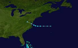
Thus, the system was designated as a subtropical storm at 1200 UTC on June 29, while centered approximately 575 miles (925 km) east of Cape Hatteras, North Carolina.
[1] Around 2200 UTC on June 30, a reconnaissance aircraft flight observed hurricane-force winds, though Bret was not upgraded to a hurricane because the minimum barometric pressure was considered too high.
[2] About an hour later, the National Hurricane Center noted that Bret was moving westward toward Virginia at 20 mph (25 km/h) and entering a region of colder sea surface temperatures, causing further intensification to become unlikely.
[1] In its early stages, the subtropical precursor of Bret tracked north of Bermuda and dropped light rainfall on the island, peaking at 3.34 inches (85 mm).
At 2000 UTC on June 30, a gale-force warning was issued for a portion of the North Carolina coastline extending from Cape Hatteras northward, including Albemarle and Pamlico sounds.
[5] Officials in North Carolina closed off beaches at Nags Head, Kitty Hawk, and Kill Devil Hills from swimmers due to rip currents and tides.
[10] In Virginia, Bret produced relatively light rainfall, peaking at 4.48 inches (114 mm) in Big Meadows, a section of Shenandoah National Park.
[4] At the time of Bret's landfall, portions of the Mid-Atlantic states were experiencing a strong drought, though the amounts of precipitation were not enough for farmers in Virginia to save their crops.
[15] Locally heavy rainfall in western Pennsylvania flooded streets and basements in some areas, with up to 4 inches (100 mm) of precipitation in Brookville.
Tropical storm (39–73 mph, 63–118 km/h)
Category 1 (74–95 mph, 119–153 km/h)
Category 2 (96–110 mph, 154–177 km/h)
Category 3 (111–129 mph, 178–208 km/h)
Category 4 (130–156 mph, 209–251 km/h)
Category 5 (≥157 mph, ≥252 km/h)
Unknown
