Tropical Storm Danas (2019)
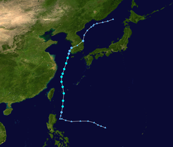
On July 11, a low-pressure zone formed near the Mariana Islands, and the United States Naval Research Laboratory began tracking the system.
[citation needed] At 8 pm, the Joint Typhoon Warning Center gave the system a low chance for tropical cyclogenesis.
On the morning of July 15, the JMA issued a gale warning, and the Central Weather Bureau (CWB) of Taiwan upgraded it to a tropical depression.
[citation needed] The weakening trend also accelerated on July 20 due to the drop in sea surface temperatures to 23 °C (73 °F) near landfall.
[1] At 12:45 UTC on July 21, Danas transitioned into an extratropical low in the Sea of Japan, and the JMA issued their final advisory on the storm.
Map key
Tropical depression (≤38 mph, ≤62 km/h)
Tropical storm (39–73 mph, 63–118 km/h)
Category 1 (74–95 mph, 119–153 km/h)
Category 2 (96–110 mph, 154–177 km/h)
Category 3 (111–129 mph, 178–208 km/h)
Category 4 (130–156 mph, 209–251 km/h)
Category 5 (≥157 mph, ≥252 km/h)
Unknown
Tropical storm (39–73 mph, 63–118 km/h)
Category 1 (74–95 mph, 119–153 km/h)
Category 2 (96–110 mph, 154–177 km/h)
Category 3 (111–129 mph, 178–208 km/h)
Category 4 (130–156 mph, 209–251 km/h)
Category 5 (≥157 mph, ≥252 km/h)
Unknown
Storm type