Tropical Storm Vicente (2018)
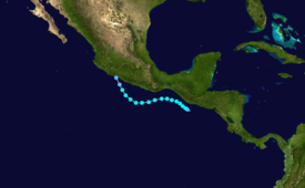
The 21st named storm of the 2018 Pacific hurricane season, Vicente originated from a tropical wave that departed from Africa's western coast on October 6.
The heavy rainfall caused numerous rivers to spill their banks, dozens of landslides to occur, and severe flooding to ensue elsewhere.
[2] Over the next several hours the system rapidly organized, becoming a tropical depression at 06:00 UTC, while located about 90 mi (150 km) west-southwest of Puerto San Jose, Guatemala.
The depression's development was not anticipated due to its small size and the close proximity of a larger disturbance to the west (which later become Hurricane Willa).
[1] The nascent depression was located in an environment of low wind shear and warm 82–84 °F (28–29 °C) sea surface temperatures, both conducive for further intensification.
[3] The structure of the unusually small storm continued to improve, with satellite and microwave imagery showing an increase in banding features around the center.
[1] Early on October 20, increasing northwesterly wind shear disrupted Vicente, causing the degradation of its central dense overcast.
[1] The tiny tropical cyclone's structure improved over the next several hours, with the storm displaying a sporadic eye feature surrounded by medium to weak convection.
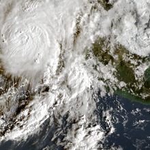
[5] Vicente peaked at 18:00 UTC on October 20 with maximum sustained winds of 50 mph (85 km/h) and a minimum central pressure of 1,002 mbar (29.59 inHg).
[1][6] Dry air began to entrain into the mid-levels of the system on October 21, causing convection to weaken and the low-level center to become uncovered once more.
The structure of Vicente markedly improved while it experienced a brief reprieve from the onslaught of the dry air; a banding feature with cold cloud tops of −112 °F (−80 °C) developed and wrapped around a majority of the storm.
Banding features decreased significantly and only limited convection remained, displaced to the south and east of Vicente's center.
[11] The threats posed by both Vicente and Hurricane Willa forced the Norwegian Bliss cruise ship to divert to San Diego, California.
[15] Ventura Puente, Carlos Salazar, Jacarandas, Los Manantiales, and Industrial experienced flooding up to 1 m (3.3 ft) deep, which left hundreds of homes inundated.
[16] Residents were evacuated from the Jacarandas neighborhood by state officials and police officers after rainfall caused a gasoline leak to occur.
The heavy rainfall also caused the ground to give way near Atapaneo, resulting in a freight train derailment that left two workers injured.
[22] Plan DN-III-E was activated to disperse aid to the state; a Mexican Air Force helicopter was utilized to get food and supplies to people in affected areas.
[43] The World Heritage city of Tlacotalpan prepared for the overflow of the Papaloapan river by creating levees to prevent floodwaters from affecting historical and cultural sites.
[28][47] The San Juan river spilled its banks, completely blocking the Tinaja-Cosoleacaque highway, a road that connects other states to Veracruz.
Federal Police stopped cars from crossing a section of the Cosamaloapan-Acayucan highway after the same river left 8 km (5.0 mi) of the road completely submerged under water.
[48] Several communities were inundated in Hidalgotitlán after the Coatzacoalcos river overflowed; 790 homes were flooded in the towns of Ramos Millán and Vicente Guerrero.
[53] Due to the unsettled weather produced by Vicente and the nearby Willa, numerous oil tankers were unable to unload fuel at ports in Manzanillo, Colima, and Tuxpan, Veracruz.
Combined with the closure of a major pipeline that transports petroleum to Guadalajara, this caused a fuel shortage in Jalisco, with some 500 gas stations being affected.
[54] Damage to gasoline distribution centers in Manzanillo and Tuxpan as well as a refinery in Salamanca, Guanajuato, led to shortages in Jalisco, Nayarit, and Colima.
[58] The storm felled 16 trees in Zihuatanejo; sewers were congested with garbage, leading to street flooding in multiple places throughout the city.
Tropical storm (39–73 mph, 63–118 km/h)
Category 1 (74–95 mph, 119–153 km/h)
Category 2 (96–110 mph, 154–177 km/h)
Category 3 (111–129 mph, 178–208 km/h)
Category 4 (130–156 mph, 209–251 km/h)
Category 5 (≥157 mph, ≥252 km/h)
Unknown