Tropical cyclone track forecasting
Benito Viñes, S.J., introduced a forecast and warning system based on cloud cover changes in Havana during the 1870s.
In 1895, it was noted that cool conditions with unusually high pressure preceded tropical cyclones in the West Indies by several days.
Despite the issuance of hurricane watches and warnings for systems threatening the coast, forecasting the path of tropical cyclones did not occur until 1920.
[3] The launch of the first weather satellite, TIROS-I, in 1960, introduced new techniques to tropical cyclone forecasting that remain important to the present day.
Within 36 hours of the center passage, the pressure begins to fall and a veil of white cirrus clouds approaches from the cyclone's direction.
Within 18 hours of the center's approach, squally weather is common, with sudden increases in wind accompanied by rain showers or thunderstorms.
When the center arrives with a strong tropical cyclone, weather conditions improve and the sun becomes visible as the eye moves overhead.
[5] For example, the beta effect will allow a tropical cyclone to track poleward and slightly to the right of the deep layer steering flow while the system lies the south of the subtropical ridge.
It is a more common phenomenon in the northern Pacific Ocean than elsewhere, due to the higher frequency of tropical cyclone activity which occurs in that region.
[7] Small wobbles in a tropical cyclone's track can occur when the convection is distributed unevenly within its circulation.
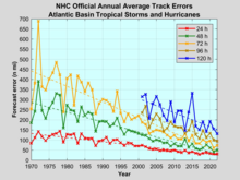
[11] Starting in the mid to late 1990s, research into tropical cyclones and how forecast models handle the systems led to substantial improvements in track error.
In addition, at 1700 UTC during the hurricane season, a medium-range coordination call takes place between the Hydrometeorological Prediction Center and the National Hurricane Center to coordinate tropical cyclone placement on the medium-range pressure forecasts 6 and 7 days into the future for the northeast Pacific and Atlantic basins.
The radius of each circle is equal to encompass two-thirds of the historical official forecast errors for the preceding five-year period.
The National Hurricane Center states that the entire track of the tropical cyclone "can be expected to remain within the cone roughly 60–70% of the time.