Hurricane Hermine
After being designated on August 29, Hermine shifted northeastwards due to a trough over Georgia and steadily intensified into an 80 mph (130 km/h) Category 1 hurricane just before making landfall in the Florida Panhandle during September 2.
[11] Initially, the system moved quickly westward with a forward speed averaging about 23 mph (37 km/h), but slowed down considerably after the northern portion of the wave split off on August 26.
[2] The low pressure area crossed the southern Bahamas with scattered convection,[12] becoming more defined on August 27 while moving near the northern Cuban coast.
[16] Based on the observations and the convective organization, it is estimated that Tropical Depression Nine developed at 18:00 UTC on August 28 while situated about 60 mi (100 km) south-southeast of Key West, Florida.
[2] Deep convection increased further as the depression moved more into the Gulf of Mexico,[17] steered by a ridge over southern Florida,[18] although it remained ragged and displaced from the circulation.
[21] Later that day, reports from the Hurricane Hunters indicated that the depression intensified into Tropical Storm Hermine about 395 mi (640 km) southwest of Apalachicola, Florida.
[22] Late on August 31, Hermine began accelerating to the northeast, influenced by a developing mid-level trough over the southeastern United States.
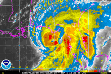
[26] Additionally, a ragged eye became visible on satellite imagery on September 1, and at 18:00 UTC, Hermine intensified into a Category 1 hurricane on the Saffir–Simpson scale.
[27] At around 05:30 UTC (1:30 a.m. EDT) that day, Hermine made landfall just east of St. Marks, Florida, at peak intensity, with a minimum pressure of 981 mbar (hPa; 29.00 inHg).
[31] With the convection far ahead of the circulation, Hermine transitioned into an extratropical cyclone at 12:00 UTC on September 3 as it emerged into the Atlantic Ocean from the Outer Banks of North Carolina.
[2] Dry air wrapped into the eastward-moving center,[32] while convection pulsed north of the former hurricane, possibly due to the warmer waters of the Gulf Stream.
[36] At 18:00 UTC on September 6, the NHC ceased issuing advisories on the post-tropical cyclone as Hermine continued to weaken amid cooler waters and convective stability.
[37] The remnants continued to meander offshore New Jersey and Long Island, eventually dissipating near Chatham, Massachusetts late on September 8.
As Hermine approached and moved up the coast, tropical storm warnings were in place as far south as Marineland, and as far northeast as Sagamore Beach, Massachusetts, including portions of the Tidal Potomac River, the Chesapeake and Delaware bays, Long Island Sound, New York City, Block Island, Martha's Vineyard, Nantucket, and Cape Cod.
[38] In response to the then-developing storm, early voting for the primary election on August 30 was extended by one day in Bradford, Broward, Charlotte, Duval, Hillsborough, Miami-Dade, Orange, Osceola, Palm Beach.
[41] Hermine affected the east coast of the United States during the busy Labor Day weekend, causing many beaches to be closed in Delaware, New Jersey, and New York.
[42] In Charleston, South Carolina, the city government provided 3,000 sandbags to residents, preparing less than a year after damaging floods hit the state.
Outer Banks ferry service was cancelled[43] and bridges in Dare County, North Carolina, were closed due to the high winds.
Officials deployed or readied swift water teams, helicopters, and the North Carolina National Guard in the eastern portion of the state.
[44] On Antigua, a lightning strike produced by thunderstorms associated with the precursor tropical wave severely damaged two 69 kV transmission lines, causing an island-wide blackout on August 24.
[50] The Zaza Reservoir – the largest in Cuba – increased its total water volume by 495,000,000 cubic feet (14,000,000 m3), bringing the levels to 30% capacity.
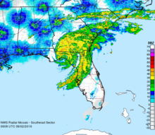
[69] Heavy rainfall in the Tampa Bay Area flooded streets, causing cars to stall, and forced people to evacuate their homes.
[56] Power outages affected the local wastewater treatment plant, causing 938,000 US gallons (3,550,000 L) of partially treated sewage to flow into Hillsborough Bay.
[75] In Lake County, wind gusts estimated at 58 mph (93 km/h) downed trees and power lines in several cities, including Clermont, Eustis, Groveland, Mascotte, Mount Dora, and Tavares.
In Collier County, coastal flooding left docks and low-lying streets under water, including State Road 92 near Goodland Bay.
[41][43][82][83] In Georgia, Hermine's winds knocked down trees onto cars and homes, resulting in several injuries in the subsequent cleanup process, although there was no major damage.
[86] The storm downed a number of trees and power lines, with hundreds falling in Valdosta, resulting in the closure of about 90 roads throughout Lowndes County.
A tree also struck a liquid oxygen tank at the medical center in Summerville, causing a leak that forced the closure of all entrances to the complex.
In Citrus, Dixie, Franklin, Jefferson, Lafayette, Leon, Levy, Liberty, Madison, Pasco, Pinellas, Suwannee, Taylor, and Wakulla counties, money was allotted to state and local governments as well as some private, nonprofit organizations on a cost-sharing basis; this fund allowed for emergency work on or replacement of buildings damaged by the storm.
These disaster centers were staffed by representatives of FEMA, the Florida Division of Emergency Management, the Small Business Administration, and other state agencies.

Tropical storm (39–73 mph, 63–118 km/h)
Category 1 (74–95 mph, 119–153 km/h)
Category 2 (96–110 mph, 154–177 km/h)
Category 3 (111–129 mph, 178–208 km/h)
Category 4 (130–156 mph, 209–251 km/h)
Category 5 (≥157 mph, ≥252 km/h)
Unknown