Typhoon Chaba (2004)
Typhoon Chaba was the strongest tropical cyclone in the western Pacific during 2004 and caused a swath of damage from the Mariana Islands to Japan from August through September of that year.
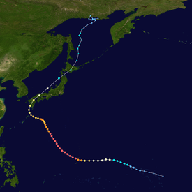
Tracking westward, the system gained tropical storm strength the following day and reached typhoon intensity on August 20.
Rapid intensification ensued thereafter, with Chaba quickly attaining its peak intensity on August 23 as it began to curve towards the northeast.
The typhoon caused significant damage to areas of the Northern Mariana Islands, which were buffeted by strong typhoon-force winds.
Gusts peaked at 219 km/h (136 mph) at Rota International Airport, and the strong winds damaged and destroyed a multitude of homes.
Within an area of favorable atmospheric conditions,[1] the system became sufficiently organized to be classified as a tropical depression by the Japan Meteorological Agency (JMA) at 0600 UTC that day.
[1] Strengthening at a climatologically normal pace,[3] Chaba reached severe tropical storm intensity at 0000 UTC on August 20.
Early on August 21, microwave imagery showed that Chaba had developed a large cloud-filled eye, signifying additional strengthening.
[1] At 1800 UTC on August 20, the JMA upgraded Chaba to typhoon status,[2] while the system was roughly 345 km (214 mi) east-southeast of Saipan.
Concurrently Chaba began to curve towards the northwest around the periphery of the nearby, dominant subtropical ridge in response to an approaching longwave,[3] sweeping past the Mariana Islands.
[1] At 1800 UTC on August 23, the JMA assessed the typhoon to have reached its peak intensity with maximum sustained winds of 205 km/h (127 mph) and a minimum barometric pressure of 910 mbar (hPa; 26.87 inHg).
[1] On August 27, the longwave trough that had in part steered Chaba northward moved out of the region,[3] and after slowing down, the typhoon began to assume a westerly course.
A second longwave trough propelled Chaba towards the north-northeast,[1] bringing it to a landfall near Kushikino, Kagoshima at 0000 UTC on August 30,[3] with sustained winds of 150 km/h (93 mph).
[2] Chaba quickly crossed Kyushu and briefly emerged over water before making a second landfall on Hōfu, Yamaguchi.
Racing towards the northeast, the storm made its final landfall as a tropical system near Oshamambe, Hokkaido on August 31 shortly before transitioning into an extratropical cyclone.
[1][2] On August 22, emergency shelters on Guam and the Northern Mariana Islands were opened in anticipation of Chaba, in response to area-wide typhoon warnings.
[7] As Chaba was slowly tracking westward on August 28, the JMA projected the storm to make landfall on western or southwestern Japan the next day, and anticipated heavy rainfall across several prefectures.
On August 21 on Marpi Point Field in Saipan, a large wave resulted in a fatality and caused another person to become hospitalized.
Rota was positioned beneath Chaba's eyewall for several hours, resulting in extremely heavy rain and strong winds.
At the coast, the storm surge from Chaba caused coastal inundation up to 3.4 m (11 ft) inland, resulting in beach erosion.
Won Pat International Airport, which had remained closed through the duration of the storm, wind gusts peaked at 109 km/h (68 mph).
[15] However, on August 25, after Chaba had begun moving away from Guam, four people were swept to sea by strong rip currents caused by the departing typhoon.
[12] Striking the largest part of Kagoshima Prefecture on August 30, the typhoon caused heavy losses to agriculture and infrastructure.
[29] The Japan Ground Self-Defense Force was dispatched in both Miyazaki and Kagoshima prefectures to rescue impacted persons and search for missing people.
Initially headed for Kure, Hiroshima, four of the ship's twenty crew members were thrown into the sea and went missing prior to the grounding incident.
Combined impacts of precipitation, storm surge, and strong winds caused numerous transportation delays and cancellations.
Tropical storm (39–73 mph, 63–118 km/h)
Category 1 (74–95 mph, 119–153 km/h)
Category 2 (96–110 mph, 154–177 km/h)
Category 3 (111–129 mph, 178–208 km/h)
Category 4 (130–156 mph, 209–251 km/h)
Category 5 (≥157 mph, ≥252 km/h)
Unknown

