Tropical Storm Chanthu (2004)
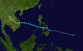
Originating from an area of low pressure on June 5, 2004, Chanthu was first declared a tropical depression near southern Leyte Island in the Philippines.
Tracking west-northwestward, the depression intensified into a tropical storm over the central Philippines before entering the South China Sea.
Severe Tropical Storm Chanthu originated out of a weak area of low pressure associated with disorganized deep convective activity located about 480 kilometres (300 mi) east-southeast of Yap on June 5.
The same day, the depression entered the Area of Responsibility (AoR) of the Philippine Atmospheric, Geophysical and Astronomical Services Administration and was given the local name Gener.
[1] At 0000 UTC on June 9, the JTWC designated the depression as Tropical Storm 08W while located about 795 km (495 mi) southeast of Manila, Philippines.
Rapidly tracking towards the west-northwest in response to a subtropical ridge to the north, the storm traversed the Philippine islands by June 10.
Due to the interaction with land, the storm rapidly weakened, with the JMA classifying it as a tropical depression early on June 13.
The families of the fishermen were each given 10 million VND (US$560) in cash and gifts by National Assembly Deputy Chairman Truong Quang Duoc.
Tropical storm (39–73 mph, 63–118 km/h)
Category 1 (74–95 mph, 119–153 km/h)
Category 2 (96–110 mph, 154–177 km/h)
Category 3 (111–129 mph, 178–208 km/h)
Category 4 (130–156 mph, 209–251 km/h)
Category 5 (≥157 mph, ≥252 km/h)
Unknown