Typhoon Maysak (2015)
The next day, the Japan Meteorological Agency (JMA) upgraded the depression to a tropical storm and assigned it the name Maysak.
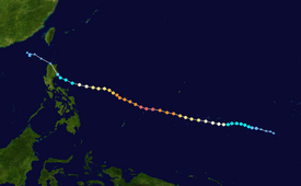
After maintaining that intensity for 18 hours, Maysak weakened, made landfall over the Philippine island of Luzon as a minimal tropical storm, and dissipated shortly afterwards.
Initially, it consisted of a broad but consolidating circulation, with outflow to the north offsetting moderate wind shear to aid in development.
[9] On March 28, microwave satellite imagery revealed an eye with central dense overcast obscuring most of the feature;[10] accordingly, the JMA upgraded Maysak to a severe tropical storm.
[6] The storm continued to strengthen while moving westward along the periphery of a subtropical ridge,[10] The eye became more defined and the convection became more consolidated.
[12][13] The storm developed good outflow, enhanced by a strong northerly flow,[14] although moderate wind shear kept Maysak from intensifying more quickly.
[17] The JTWC reported a 30 km (19 mi) wide eye displaying the stadium effect, and surrounded by very deep convection.
[18] At peak intensity, Maysak had a nearly symmetric eye with an almost perfect ring of convection around it, with characteristics of an annular tropical cyclone.
[21] On April 1, the eye widened to about 40 km (25 mi) after undergoing an eyewall replacement cycle,[22] and the storm began to weaken,[6] with diminished intensity of the convection.
[23] The convection weakened significant in the storm's southern quadrant due to drier air and worsening upper-level conditions.
[24] On April 1, the Philippine Atmospheric, Geophysical and Astronomical Services Administration (PAGASA) started tracking Maysak, giving it the local name Chedeng.
According to the United States Agency for International Development (USAID), a total of 29,000 people were directly affected by the storm and damage throughout the FSM amounted to $8.5 million.
[32] The storm later struck Chuuk State on March 29, passing directly over the main island as a Category 1-equivalent typhoon,[12] with gusts as high as 175 km/h (109 mph).
[33] High sustained winds, measured up to 114 km/h (71 mph) at the local National Weather Service office, downed numerous trees, power lines, and tore off roofs.
[33] Two days after striking Chuuk, Maysak passed directly over Ulithi atoll and skirted Fais Island at peak intensity, resulting in extensive damage.
[44] Striking the Philippines as a rapidly weakening system, Maysak had only minimal effects in the country,[44] producing strong waves and light rainfall.
[42] Across Aurora and Isabela provinces, a total of 2,761 people were directly affected by the storm, most of whom were evacuated prior to Maysak's landfall.
No damage or loss of life was reported; however, four people were injured after waves generated by Maysak hit them while they were taking selfies along the shoreline of Dipaculao town in Aurora province on April 4.
The Philippine Coast Guard stated that seas at the time were calm and the sinking likely resulted from overcrowding of the vessel rather than Typhoon Maysak.
[47] On April 9, the Congress of the Federated States of Micronesia held a special two-day session at the request of President Manny Mori, which included determination of typhoon relief funds.
[53] USAID transported relief goods and $2.1 million worth of aid, including reverse osmosis kits and water distribution tanks.
Tropical storm (39–73 mph, 63–118 km/h)
Category 1 (74–95 mph, 119–153 km/h)
Category 2 (96–110 mph, 154–177 km/h)
Category 3 (111–129 mph, 178–208 km/h)
Category 4 (130–156 mph, 209–251 km/h)
Category 5 (≥157 mph, ≥252 km/h)
Unknown


