Typhoon Flo (1993)
Slight wind shear from nearby Ed inhibited development; however, it intensified to a minimal typhoon as it neared the coastline of Luzon.
[2] A persistent and broad area of convection was first mentioned by the Joint Typhoon Warning Center (JTWC) on September 28 for possible tropical cyclogenesis, to the northwest of Palau.
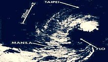
[3][4] The next day, the Japan Meteorological Agency (JMA) reported that the area of convection coalesced to a tropical depression, located approximately 970 km to the east-northeast of Manila, Philippines.
[8][6] At first, Flo is forecasted to move through the west, making landfall in South China; however, due to these circumstances, the system accelerated even closer to the country.
[2][10] Sea vessels and large cargo boats were advised to dock in a safe place due to possible storm surge and the Department of Education suspended primary and secondary classes.
[11] Isabela, Cagayan, Ifugao, and several other nearby provinces, including the populous Metro Manila have been placed on storm alerts.
[12] The Philippine President at that time, Fidel V. Ramos, approved ₱10.2 million ($360,000) from the calamity fund for food packs that would be given to the evacuees.
[2] Between 02:00 and 04:00 UTC, Flo (known as Kadiang in the Philippines) made landfall between Isabela and Aurora coastline, causing large storm surges.
[15][8][16] In the capital Manila, strong winds broke the moorings of a barge and another small freighter, pushing them to the shorelines of the Roxas Boulevard.
[2] As reported by the National Disaster Coordinating Council, the total damages from the typhoon were estimated at ₱5.3 billion ($188 million, 2005 USD).
[7][24] President Fidel Ramos declared vast majority of Northern Luzon in state of calamity due to the catastrophic effects of Flo in the Philippines.

Tropical storm (39–73 mph, 63–118 km/h)
Category 1 (74–95 mph, 119–153 km/h)
Category 2 (96–110 mph, 154–177 km/h)
Category 3 (111–129 mph, 178–208 km/h)
Category 4 (130–156 mph, 209–251 km/h)
Category 5 (≥157 mph, ≥252 km/h)
Unknown