Typhoon In-fa
[7] At 20:30 UTC of the next day, the agency upgraded the system's potential trend of intensification to "high" and issued the disturbance's Tropical Cyclone Formation Alert (TCFA).
[14][15][16] Later, a pocket of dry air from the western semicircle and upper-level westerlies disrupted the system, with the LLC becoming broad and exposed while slowly and steadily intensifying, with the evidence of cooling cloud tops.
At the same time, the system began to take a northwest track before moving west-northwestward under a subtropical ridge over Japan by the early hours of July 19.
[31][32] Six hours later, the PAGASA reported in their bulletins that In-fa further became a typhoon, while located approximately 895 kilometres to the east of extreme Northern Luzon.
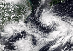
[34][35] As it passed south of Daito Islands, a 35-nautical-mile (65 km; 40 mi) eye was further evident on satellite imageries, which later shrunk; however, In-fa remained a high-end Category 1 system as it started to move westward and later, a west-southwest track.
The system further degraded to a tropical storm according to the estimates of JTWC, six hours later as it slowly moved away from the Ryukyu Islands and the convection on the eye was not continuous while subsequently entering the East China Sea.
[47][48] By 03:00 UTC on the next day, In-fa reintensified to a low-end Category 1 system as it reformed its convective depths and continued to maintain a ragged eye while moving northward.
[49] Six hours later (23:00 PST of July 23), In-fa left the PAR, with the PAGASA issuing its last bulletin while located, 640 kilometres to the north-northeast of Itbayat, Batanes.
[50] The JMA then analysed that In-fa further reached its peak with maximum sustained winds of 150 km/h (90 mph) and a minimum barometric pressure of 950 hPa (28.05 inHg), three hours later.
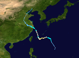
[52] At 04:30 UTC on the next day, the system made its first landfall in the eastern Chinese province of Zhejiang, over Putuo District, a major port area in the city of Zhoushan.
[53] Four and a half hours later, the JTWC quickly downgraded the system to a tropical storm as its eye became ill-defined and the central dense overcast further became evident on satellite imageries instead of the former.
[55] Although tracking inland south of Shanghai, In-fa's overall structure remained compact and its gale-force winds further expanded, although as it reentered the East China Sea from Zhoushan, the core of the system slowly eroded.
[56][57] At 01:30 UTC of July 26, the large storm made its second coastal landfall over Pinghu, Jiaxing with maximum sustained winds of 40 knots (75 km/h; 45 mph) from the west-northwest.
[61] At 00:00 UTC of the next day, the JMA reported that In-fa further degraded to a tropical depression while moving west-northwest, with its center located at Shou County, Anhui Province.
[63][64] By 06:00 UTC of July 29, the system turned northward yet again before being further downgraded by JMA as a low-pressure area, twelve hours later as it shifted its movement northeastward.
[68] In the Ryukyu Islands, the Okinawa Meteorological Observatory held a meeting on July 17 to discuss the storm, warning people to be cautious of the approaching system.
[82] A school in Kitadaitō, Okinawa was temporarily closed due to the storm while roadways on the village were shut down, starting on July 19.
[84] Despite the depression being far away from any landmasses in the Philippines, the storm (locally known as Fabian in the country) was forecasted to enhance the prevailing southwest monsoon, causing rains over Luzon and the Visayas.
[85][86] Brought by the enhanced southwest monsoon from the system and Cempaka, heavy rainfall warnings were put in effect by PAGASA for Metro Manila and several other provinces nearby.
On the next day, a heavy rain advisory was issued by the CWB for the northern portion of the country (except Yilan County) and later, the area was further included.
[95] Different offices and schools in the northwest portion of the country were forced to close temporarily due to the threats of landslides and heavy rains.
Flooding of some kind had affected a myriad of provinces, prefectures, and regions in countries, with thousands of buildings being damaged in some way over the course of the typhoon, along with severe impacts to agriculture.
[118] An office in Nanjō suffered power, internet signal and telecommunication loss due to In-fa, while a disaster headquarters at Naha urged people to evacuate as the conditions started to become rough as the storm neared.
A vinyl house was reported to have collapsed in Yonagusuku, Yaese, while a telephone line in Nanjō City office were cut due to the storm.
[123] A stone pile, which were around for 10 years also collapsed and the 250-year old historic Nakadou no San-ban Akou tree's large branches in Ishigaki Island were downed due to strong winds from In-fa.
[121] Nine individuals were reported injured in the other hand, including an elderly woman on July 20 when she fell in the parking lot of a hotel in Minama, Chatan and two more in Miyako-jima.
[133] On July 24, the Marikina River overflowed its banks, reaching 16 meters high as the combined effects of In-fa and the southwest monsoon continued to pour rainfall over the region.
The municipal's anti-flood commanding office reported that among the 654 meteorological monitoring stations around the city, 30 recorded 70 mm (2.8 in) of rainfall in 12 hours.
[116] A rail freight train going from China to Europe was disrupted while cargo was being reconfigured to other substitute terminals, adding pressure to already heavy-hit shipping industry.
[4] $58,200 worth of Family Food Packs were distrusted to the affected population in Calabarzon, Central Luzon, Mimaropa, and Western Visayas on July 26.
Tropical storm (39–73 mph, 63–118 km/h)
Category 1 (74–95 mph, 119–153 km/h)
Category 2 (96–110 mph, 154–177 km/h)
Category 3 (111–129 mph, 178–208 km/h)
Category 4 (130–156 mph, 209–251 km/h)
Category 5 (≥157 mph, ≥252 km/h)
Unknown