Typhoon Kathleen
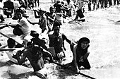
[1] Kathleen brought record heavy rain at the time, causing major destruction in the Kanto region.
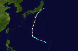
Kathleen struck the Boso Peninsula and the entire Kanto Region in Japan on September 15.
[3] The areas of Tokyo, Gunma, Saitama, Tochigi, Ibaraki and Chiba suffered severe flood damage.
[3] Also, in the Tohoku region, the Kitakami River flooded, causing major damage at Ichinoseki City in Iwate Prefecture.
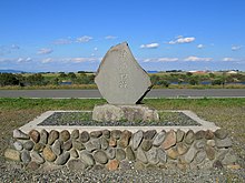
[5] There is a memorial built for the victims of typhoon at Kazo City, Saitama Prefecture.
Map key
Tropical depression (≤38 mph, ≤62 km/h)
Tropical storm (39–73 mph, 63–118 km/h)
Category 1 (74–95 mph, 119–153 km/h)
Category 2 (96–110 mph, 154–177 km/h)
Category 3 (111–129 mph, 178–208 km/h)
Category 4 (130–156 mph, 209–251 km/h)
Category 5 (≥157 mph, ≥252 km/h)
Unknown
Tropical storm (39–73 mph, 63–118 km/h)
Category 1 (74–95 mph, 119–153 km/h)
Category 2 (96–110 mph, 154–177 km/h)
Category 3 (111–129 mph, 178–208 km/h)
Category 4 (130–156 mph, 209–251 km/h)
Category 5 (≥157 mph, ≥252 km/h)
Unknown
Storm type