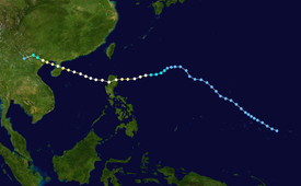
Typhoon Krovanh (2003)
The fifteenth named storm and sixth typhoon in the western Pacific that year, Krovanh originated from a tropical disturbance within the monsoon trough on August 13.
Despite rather favorable conditions, the initial tropical depression did not intensify significantly and degenerated into a remnant low on August 18.
[nb 2] The typhoon emerged into the South China Sea as a much weaker tropical storm, though it was able to restrengthen over warm waters.
Once again at typhoon intensity, Krovanh clipped Haiyan before moving over the Leizhou Peninsula on its way to a final landfall near Cẩm Phả, Vietnam on August 25.
Quick weakening due to land interaction occurred as Krovanh moved across northern Vietnam, where the storm met its demise the following day.
In Hong Kong, eleven people were injured and isolated flooding occurred as a result of the typhoon's outer rainbands.
[nb 3] Due to its positioning and track, of all areas in Vietnam only the country's more northern regions were impacted by Krovanh.
The origin of Typhoon Krovanh can be traced back to an area of persistent convection well east of Chuuk State on August 13.
[2] Shower activity was suppressed by a nearby upper-level low for much of the storm's early existence;[1] however, at 0600 UTC on August 15, the system was classified by the Joint Typhoon Warning Center (JTWC) as a tropical depression.
[3] Strengthening and development of the tropical cyclone was very minimal over the next few days, and on August 18, both tracking agencies discontinued monitoring the system due to the lack of an identifiable low-level circulation center.
[1] Redevelopment of the disturbance was a possibility following its degeneration, and on August 19, convection once again increased, prompting the JTWC to resume monitoring the system as a tropical depression at 0900 UTC, with the JMA following suit nine hours later.
[1] At 0600 UTC on August 20, the JTWC determined that the disturbance had intensified to reach tropical storm status.
[3] On August 22, the JMA reassessed Krovanh as a typhoon and determined that the storm had reached its peak intensity with winds of 120 km/h (75 mph).
[1] During this time, the JMA upgraded Krovanh back to typhoon intensity and indicated that the storm was reaching a secondary peak in strength.
Over land, Krovanh deteriorated rapidly, and both agencies ceased monitoring the system on August 26 while it was well northwest of Hanoi.
[1][5] As Krovanh was approaching the Philippines, Taiwan's Central Weather Bureau cautioned the residents of the island against strong winds and warning ships in the Bashi Channel.
In preparation for the storm, shipping routes across the Qiongzhou Strait were suspended, while security measures for river dykes and reservoirs were strengthened in both Hainan and Guangdong.
Tropical storm (39–73 mph, 63–118 km/h)
Category 1 (74–95 mph, 119–153 km/h)
Category 2 (96–110 mph, 154–177 km/h)
Category 3 (111–129 mph, 178–208 km/h)
Category 4 (130–156 mph, 209–251 km/h)
Category 5 (≥157 mph, ≥252 km/h)
Unknown

