Typhoon Koryn (1993)
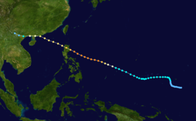
On June 23, satellite photos revealed a 10-mile (16 km) diameter eye forming in the developing storm and winds of 75 mph (121 km/h) were also detected, prompting forecasters to upgrade Koryn to typhoon status.
The next day, Koryn rapidly intensified to become the first super typhoon of the season with winds of 150 mph (240 km/h) and a minimal pressure of 905 millibars.
[1] After peaking, the typhoon began to weaken and started making landfall in the northern Philippines.
After making landfall in the northern Philippines on June 26, Koryn entered the South China Sea as a Category 2 typhoon.
[1] In China, officials began to issue gale warnings as the typhoon was 220 miles (350 km) from making landfall.
Map key
Tropical depression (≤38 mph, ≤62 km/h)
Tropical storm (39–73 mph, 63–118 km/h)
Category 1 (74–95 mph, 119–153 km/h)
Category 2 (96–110 mph, 154–177 km/h)
Category 3 (111–129 mph, 178–208 km/h)
Category 4 (130–156 mph, 209–251 km/h)
Category 5 (≥157 mph, ≥252 km/h)
Unknown
Tropical storm (39–73 mph, 63–118 km/h)
Category 1 (74–95 mph, 119–153 km/h)
Category 2 (96–110 mph, 154–177 km/h)
Category 3 (111–129 mph, 178–208 km/h)
Category 4 (130–156 mph, 209–251 km/h)
Category 5 (≥157 mph, ≥252 km/h)
Unknown
Storm type