Typhoon Manny
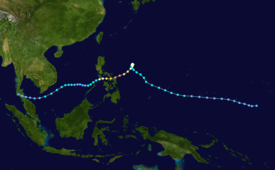
The twenty-ninth named storm and fifteenth typhoon of the season, the system formed from a near-equatorial trough that also spawned Lola during the month in the east Caroline Islands on December 3.
It then rapidly intensified while moving to the southwest, with the typhoon reaching its peak of 220 km/h (135 mph) and an unusually high barometric pressure of 960 mbar before crossing the central Philippines on December 10 and 11.
The Joint Typhoon Warning Center (JTWC) started to monitor an area of convection embedded from a near-equatorial trough, near Tofol in Kosrae State on December 1.
[1] At this time, the disturbance is in a marginally favorable environment, including warm sea surface temperatures and radial outflow, being offset by high wind shear, as being evidenced by satellite imagery.
[2] On the next day, the organization of the disturbance became well-defined, with the JTWC first mentioning the system in their Significant Tropical Weather Advisory, while located to the east of Pohnpei, Caroline Islands.
[1] However, as the disturbance entered yet again a hostile environment, the system became disorganized on satellite imagery as the convection became sheared to the east of its supposed low-level circulation center.
[1] In the warm waters of the Philippine Sea, the system explosively strengthened to its peak of 220 km/h (135 mph) and a minimum barometric pressure of 920 mbar while moving south-southwestward, which is equivalent to a violent Category 4 major typhoon on the Saffir-Simpson Scale.
[2] It then shifted its movement to the south-southwest, skirting the north and northeastern coasts of Palawan on December 11 as a tropical storm before moving through the South China Sea.
[2] After a day of meandering while over the South China Sea, Manny unexpectedly restrengthened to a tropical storm on December 13 near the waters of Vietnam, with bursts of scattered convection struggling to consolidate in its center, as being evidenced on satellite imagery.
[1] Since December 10, the meteorological forecasters, including the Philippine Atmospheric, Geophysical and Astronomical Services Administration (PAGASA) strictly watched the movement of the typhoon for its possible landfall and hazards.
[5] In Yap State, some residents experienced a wind speed of 38 knots from the storm, downing some banana trees and twigs, but there were no reports of affected buildings and structures.
[13] Combined reports from official and reliable sources at that time, the deaths from the typhoon were finalized at 245 individuals, missings at 66, and over 524 injured, which the majority are due to drowning and mudslides.
[15] After Manny devastated the storm-weary Philippines, then-president Fidel V. Ramos declared a state of calamity on Sorsogon, Masbate, Romblon and Northern Samar due to the catastrophic effects of the typhoon.
[5] On December 14, while the typhoon is weakening over the South China Sea, the Eastern Samar experienced a magnitude 5.3 earthquake which killed a person and injured two more.
Tropical storm (39–73 mph, 63–118 km/h)
Category 1 (74–95 mph, 119–153 km/h)
Category 2 (96–110 mph, 154–177 km/h)
Category 3 (111–129 mph, 178–208 km/h)
Category 4 (130–156 mph, 209–251 km/h)
Category 5 (≥157 mph, ≥252 km/h)
Unknown
