Typhoon Tokage
With very warm waters, the system started to undergo a rapid deepening phase early on October 13 and reached its peak strength on the 17th.
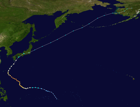
The system developed into Tropical Depression 27W at late that day, moving in a west-northwesterly at 15 kn about 200 miles east of Guam.
On the October 13, the system developed into a tropical storm, and was named Tokage, subsequently moving very close to the islands of Rota and Guam.
The storm curled towards the north as a major shortwave over weakened the subtropical ridge and by October 17 Tokage reached its peak intensity of 125 kn/145 mph.
[2][3] By October 21, the cyclone weakened into a tropical storm 130 nm west of Tokyo, and later that day, the system completed the transition to a nontropical low.
[7] A total of 95 deaths were attributed to high winds, flooding and mudslides caused by Tokage, with an additional three people reported missing.
Tropical storm (39–73 mph, 63–118 km/h)
Category 1 (74–95 mph, 119–153 km/h)
Category 2 (96–110 mph, 154–177 km/h)
Category 3 (111–129 mph, 178–208 km/h)
Category 4 (130–156 mph, 209–251 km/h)
Category 5 (≥157 mph, ≥252 km/h)
Unknown