Typhoon Yancy (1993)
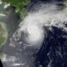
The strong tropical cyclone reached peak intensity on September 2 with maximum sustained winds of 175 km/h (109 mph).
[nb 2] In late August, an area of convection began to persist in the open northwestern Pacific, well removed from any landmasses.
The Joint Typhoon Warning Center (JTWC) started to monitor the disturbance at 1200 UTC on August 27.
[2] Aided by a southwesterly monsoonal wind flow and in an area of favorable conditions, the system organized, and at 0600 UTC on August 28, the JTWC issued a Significant Tropical Weather Advisory on the disturbance.
[3] Organization continued throughout the day's course, and the system was classified by the Japan Meteorological Agency (JMA) as a tropical depression at 0000 UTC on August 29.
[4] Shower activity at that time began to coalesce more closely around the system's center of circulation, prompting the JTWC to issue a Tropical Cyclone Formation Alert an hour later.
Based on satellite intensity estimates, the agency also reclassified the system as a tropical depression at 0600 UTC that day.
[3] At 0000 UTC on August 30, the JMA upgraded the system to tropical storm intensity,[4] followed by the JTWC six hours later based on a ship report in the vicinity of the cyclone.
[3] The JMA maintained the storm's severe tropical storm status through this period, though on September 1 the agency initiated 3-hour position fixes in contrast to their usual 6-hour fix procedure; at 0300 UTC that day the JMA upgraded Yancy to typhoon intensity.
[5] Rapid intensification ensued,[3] and just nine hours later the JTWC estimated Yancy's winds to have equated to that of a Category 3 on the Saffir–Simpson scale.
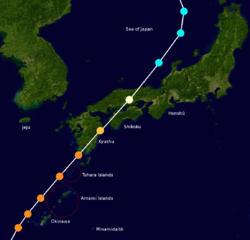
[4] Only minimal weakening occurred in the immediate hours following peak intensity, and at around 0600 UTC on September 3, Yancy passed directly over Iōjima.
[4] Tracking rapidly northeastward at around 40 km/h (25 mph),[5] Yancy made a second landfall on Kagoshima Prefecture within an hour later at the same intensity;[4] at the time this made Yancy the strongest tropical cyclone ever to make landfall on Japan since Typhoon Shirley in 1965, 28 years prior.
[3][6] Land interaction with Kyushu further weakened Yancy,[5] but the system remained at typhoon intensity upon its landfall on western Ehime Prefecture at around 1400 UTC that day.
[4][5] Yancy's extratropical remnants persisted for several days as they meandered within the Sea of Japan before dissipating by 1200 UTC on September 7.
[4] In preparation for Typhoon Yancy, bus and rail services in potentially affected areas were halted.
[7] Forecasts prior to Yancy's landfalls on Japan raised fears that the storm would be one of the strongest in the past 50 years to strike the country.
[10] As Yancy neared the country, approximately 4,600 people were forced to evacuate from flood and landslide-prone areas of Kagoshima.
[9] Pop star Michael Jackson postponed a scheduled performance in Taiwan, potentially as a result of Typhoon Yancy.
The eye of the typhoon passed directly over the island, resulting in a station observing a record low barometric pressure of 928 mbar (928 hPa; 27.4 inHg).
Total damage costs on Kume and Naha islands amounted to ¥1.8 billion (US$17.3 million), and two people were killed.
[20] Kyushu was the first of Japan's four main islands to be impacted by Yancy and suffered the worst effects as a result.
[12] High storm surge generated by Yancy caused coastal inundation in Hyūga, which flooded the first floors of many buildings.
Overall damage totaled ¥88.8 billion (US$840 million), primarily as a result of agricultural loss, and two people were killed.
[26] Ōita Prefecture was primarily impacted by heavy rainfall from Yancy, resulting in widespread flooding.
In addition to residential damage, the floods inundated large swaths of agricultural land, leading to soil erosion.
Overall, damage caused by Yancy in Ōita Prefecture was estimated at ¥42.4 billion (US$402 million), and seven people were killed.
[28] In Saga, excessive rainfall caused widespread crop damage and suspended various transportation services.
[12] A high storm surge swamped coastal regions, damaging fishing boats and other shoreline structures.
Power outage also occurred in earnest in Ehime Prefecture, with as many as 37,300 households losing electricity at one point.

Tropical storm (39–73 mph, 63–118 km/h)
Category 1 (74–95 mph, 119–153 km/h)
Category 2 (96–110 mph, 154–177 km/h)
Category 3 (111–129 mph, 178–208 km/h)
Category 4 (130–156 mph, 209–251 km/h)
Category 5 (≥157 mph, ≥252 km/h)
Unknown