U.S. Route 1 in Florida
U.S. Highway 1 (US 1) in Florida runs 545 miles (877 km) along the state's east coast from Key West to its crossing of the St. Marys River into Georgia north of Boulogne and south of Folkston.
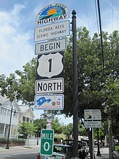
US 1 officially begins its northward journey at the Monroe County courthouse at the intersection of Whitehead and Fleming streets in Key West.
Truman Avenue becomes North Roosevelt Boulevard about a mile (1.6 km) east and remains so until leaving the island; US 1 expands to four lanes along its length.
The road follows the northern shore of this section of Key West, then after curving southward, it meets SR A1A head-on at a T intersection before continuing east.
Immediately the Overseas Highway enters Tavernier,[20] where it temporarily splits into a pair of one-way roads through the community.
Signage approaching the intersection directs northbound motorists to take this alternative route if the lights on it are flashing.
US 1 swings to the northwest, forms the southern boundary of North Key Largo,[23] and becomes a two-lane divided road after the intersection.
[12][25][26][27] For the first 14 miles (23 km) in Miami-Dade County, US 1 is a divided two-lane road bordering Everglades National Park on the west.
Just north of the Card Sound Road intersection, US 1 meets the southern end of Krome Avenue (former SR 997) and then enters Florida City.
After the two directions of traffic rejoin, the road meets Coral Reef Drive (SR 992), then passes through Rockdale and Howard until it reaches South 136th Street (Howard Drive), meets the southern terminus of SR 973 a block later, and serves to divide Pinecrest to the southeast and Kendall and Dadeland to the northwest for the next few miles.
North of Snapper Creek (Canal C-2), US 1 continues northeast and enters another section of unincorporated Miami-Dade County.
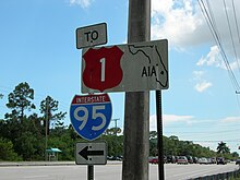
About a mile (1.6 km) east, it meets the national southern terminus of I-95, which it joins over the Miami River into downtown.
US 1 continues through Midtown Miami, intersecting with the national southern terminus of US 27 one block south of I-195 next to the Julia Tuttle Causeway.
As US 1 makes its way into Martin County, it passes through Jonathan Dickinson State Park before crossing over the Florida East Coast Railway tracks.
North of the bridge, it crosses over the Florida East Coast Railway tracks again and meets CR 707.
One and a half miles (2.4 km) north of Treasure Coast Square, US 1 leaves Martin County.
US 1 then runs parallel with the Florida East Coast Railroad, entering central Vero Beach, where it is locally known as Commerce Boulevard.
As US 1 enters Melbourne, the road veers a few blocks west of the Indian River, heading toward an intersection of US 192 at the 1900 Building.
[35] Just north of the Elbow Creek Bridge, it enters the Eau Gallie portion of Melbourne and intersects SR 518.
In Brentwood Heights, US 1 intersects CR 515 again, with US 1 resuming its status as the Indian River Lagoon Scenic Highway.
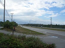
North of Titusville, US 1 steers away from the Indian River and travels in a parallel direction with I-95 from here to the Volusia County line.
It then continues to Scottsmoor, just south of the Volusia County line, where it intersects CR 5A, a one-mile (1.6 km) spur route of the road itself.
It then enters the city of Ormond Beach, where US 1 is known and Younge Street, intersecting SR 40 and running parallel with CR 4079.
US 1 enters St. Johns County at the northern end of Pellicer Creek and quickly intersects with CR 204 just south of the I-95 interchange.
After leaving St. Augustine, it passes by the western end of Northeast Florida Regional Airport and cuts through wetlands to Durbin.
At the northernmost intersection with CR 210 at Race Track Road, US 1 crosses the Duval County line and enters Jacksonville.
From St. Johns County, US 1 starts its journey through Duval County and Jacksonville at Race Track Road, where it becomes the Philips Highway, a 17-mile-long (27 km) section of US 1 south of Downtown Jacksonville named after Judge Henry Bethune Philips, the first chair of the State Road Department, predecessor of FDOT.
[36] It heads north through the sparsely developed sections of southeast Jacksonville, intersecting the future I-795 (SR 9B) interchange, followed by Old St. Augustine Road in Bayard.
US 1 then heads toward Bowden Road, providing access to southbound I-95, followed one block later by SR 109, locally known as University Boulevard.
[37] The label was generally applied to the Atlantic Highway, except between Jacksonville, Florida, and Augusta, Georgia, where a more inland route was chosen.