U.S. Route 522
The U.S. Highway travels in a north-south direction, and runs 308.59 miles (496.63 km) from US 60 near Powhatan, Virginia, to its northern terminus at US 11 and US 15 near Selinsgrove, Pennsylvania.
US 522 serves many small cities and towns in the Piedmont, Blue Ridge Mountains, and northern Shenandoah Valley of Virginia.
The highway serves the Virginia communities of Goochland, Mineral, Culpeper, the town of Washington, and Front Royal and the independent city of Winchester.
US 522 then follows the Ridge-and-Valley Appalachians north and then east through the Eastern Panhandle of West Virginia, a 2-mile-wide (3.2 km) stretch of Western Maryland, and South Central Pennsylvania to its terminus in the Susquehanna Valley.
The highway serves Berkeley Springs, West Virginia; Hancock, Maryland; and the Pennsylvania communities of McConnellsburg, Mount Union, Lewistown, and Middleburg.
The U.S. highway is part of the main system from Virginia State Route 37 (SR 37) near Winchester to Interstate 70 (I-70) at Warfordsburg, Pennsylvania.
[5][6][7][8] US 522 is a National Highway System principal arterial in four places in Virginia, including its concurrencies with SR 3 and US 15 Bus.
The two highways meet the east end of SR 329, which leads to the Virginia Correctional Center for Women, opposite the historic home Brightly.
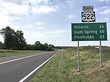
[1][10] US 522 continues north on Sandy Hook Road, which passes through the eponymous hamlet before entering Louisa County at the village of Gum Spring.
SR 208 splits east onto New Bridge Road toward Spotsylvania Courthouse, and US 522 continues northwest along the presidential-named highway.
At Winston, US 522 curves northeast and joins Rapidan Road on a tangent and begins to parallel Norfolk Southern Railway's Washington District rail line.
when it turns west onto Evans Street, which crosses Mountain Run and passes Fairview Cemetery on its way out of the town of Culpeper.
The U.S. highway passes through the hamlets of Norman and Griffinsburg and crosses Devils Run and the Hazel River south of their confluence.
US 522 and US 211 cross Battle Run just west of Massies Corner, where US 211 continues east toward Warrenton while US 522 heads north on two-lane Zachary Taylor Highway.
The highway crosses the Jordan River and three of its tributaries—Wilson Branch, Hittles Mill Stream, and Indian Run—between Flint Hill and Huntly.
From Huntly, US 522 ascends the Blue Ridge to Chester Gap, where the highway intersects the Appalachian Trail next to the headwaters of the Rappahannock River and the Rappahannock–Warren–Fauquier county tripoint.
[1][10] US 522 enters Warren County and descends to the town of Front Royal along Remount Road, which passes the historic Mountain Home along its descent along Happy Creek.
US 522 continues into Frederick County as Front Royal Pike, which passes through Armel at Wrights Run and Parkins Mills at Opequon Creek.
In the center of town, US 522 and WV 9 pass by Berkeley Springs State Park and the Morgan County Courthouse.
North of Burnt Factory, the highway descends into the narrow valley of the Potomac River; southbound US 522 has a climbing lane.
[2][11] US 522's bridge across the Potomac River begins just north of River Road; the highway crosses over CSX's Cumberland Subdivision's Hancock rail yard and, on the bridge itself, has its last junction in West Virginia, with Airport Road, which leads to Potomac Airpark in the West Virginia hamlet of Hancock.
Immediately to the north, I-70 and US 522 meet the eastern terminus of I-68 (National Freeway) at another three-level directional interchange, where westbound US 40 leaves I-70 and goes onto I-68.
The Interstate and the U.S. Highway split in Warfordsburg at Exit 168, a diamond interchange where I-70 curves northwest toward Breezewood while US 522 heads north on Great Cove Road.
US 522 heads north out of the borough into Todd Township, once again named Great Cove Road, and meets US 30 (Lincoln Highway) at a diamond interchange.
US 522 parallels the turnpike through the valley of Little Aughwick Creek northeast through Fort Littleton to the village of Burnt Cabins, Pennsylvania just north of Sidneys Knob.
Part of the route's course on Main Street is a concurrency with PA 104, with which the highway crosses Middle Creek a second time.
The U.S. Highway enters Penn Township and passes through the northern fringe of the borough of Selinsgrove, where the route meets the southern end of PA 204.
Through Maryland, Warfordsburg Road from Main Street at the west end of Hancock north to the Pennsylvania state line was paved in 1920.
In the vicinity of the proposed Ridge Historic District, however, the alignment extends farther away to avoid impacting either that site or the adjacent fish hatchery.
Also, immediately south of Berkeley Springs, the projected route would veer further east to avoid the downtown area.