Zion Canyon
The canyon begins much further upstream, however, and runs southward about 16 miles (26 km) through the Narrows to reach the Temple, where a seasonal tributary of the North Fork plunges over a tall waterfall during spring runoff and after heavy rain.
The gorge then merges with Pine Creek Canyon as it winds out of the national park and past the community of Springdale, Utah.
Hiking is permitted in the Narrows when water levels are low enough; however, flash floods are known to rise quickly following heavy rainstorms.
Many areas in the drainage of Zion Canyon have little or no soil cover, contributing to extremely brief but heavy storm runoff.
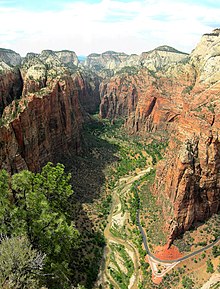
In contrast, the floor of most of the main Zion Canyon is close to 1,000 feet (300 m) wide and is rich with river-deposited sediments.
Mass wasting, often caused by ice wedging into cracks in the canyon walls, is another force that widens the valley.