Architecture of Albany, New York
The completion of the Erie Canal in 1825 triggered a building boom, which continued until the Great Depression and the suburbanization of the area afterward.
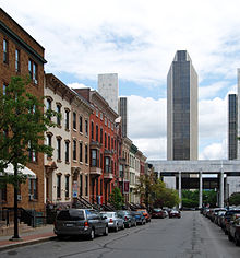
The bulk of the city's historic architecture, however, are its many rowhouses, homes to residents of both affluent neighborhoods like Center Square and poorer areas like Arbor Hill.
Architects of national stature represented among Albany's buildings include Philip Hooker, Patrick Keely, Andrew Jackson Downing and Calvert Vaux, Richard Upjohn and his son, Henry Hobson Richardson, and Stanford White.
Beyond the Slingerlands Bypass the city is bounded mostly by Normanskill Creek and its tributary Krum Kill, save for a long western protrusion that encompasses the Albany Pine Bush Preserve.
I-787 and the railroad tracks used by CSX Transportation's River Subdivision separate the industrial waterfront of the Port of Albany and parks like the Corning Preserve from the rest of the city.
it is densely developed with high-rises like the Home Savings Bank Building, joined by newer projects like the Times Union Center arena.
[2] At the crest of the bluff, just west of downtown, is the Lafayette Park Historic District, distinguished by two monumental government buildings, the state capitol.
[13] In the southeast corner is the small brick Italian villa-style James Hall Office, a National Historic Landmark now annexed to a former elementary school building.
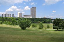
It is a contributing property to the Center Square/Hudson–Park Historic District,[17] the large residential area, its streets lined with rowhouses, that stretches past Lark Street (U.S. Route 9W), the city's main nightlife destination, to Washington Park, the city's largest, with 5.2 acres (2.1 ha) of its 81 acres (33 ha) given over to Washington Park Lake.
New Scotland Avenue, the neighborhood's northern boundary, leads out into residential areas where the rowhouses give way to frame detached houses.
It is a primarily residential area with the exception of the 48-acre (19 ha) campus of The College of St. Rose[22] and some commercial development along nearby sections of Madison and Western avenues.
South of Western are more newer residential neighborhoods; between Washington and I-90 are hotels, restaurants and gas stations serving traffic from the nearby interstate exits.
Artificial Rensselaer Lake, the city's largest body of water at 35.3 acres (14.3 ha),[26] is located just east of the junction of I-90 and the Adirondack Northway.
The distinctive rooster-comb ridgeline of the Blackhead Range in the northern Catskills, at nearly 4,000 feet (1,200 m) the highest mountains visible from the city, are to the south.
[29] The oldest building currently standing in Albany is the Van Ostrande-Radliff House at 48 Hudson Avenue;[30] scientific testing estimates it was built in 1728.
The New York State Capitol was opened in 1899 (after 32 years of construction[7]) at a cost of $25 million, making it the most expensive government building at the time.
[39] Later in the decade, Albert W. Fuller's 1917 First Congregational Church of Albany, in the then-undeveloped Woodlawn neighborhood, was the city's first to use the emerging Colonial Revival style.
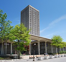
[49] The uptown SUNY campus was built in the 1960s under Governor Nelson Rockefeller on the site of the city-owned Albany Country Club.
Four dormitory complexes, each centered by a high-rise housing tower surrounded by a low-rise grouping of support buildings, are located at each corner of the podium.
The architecture called for much use of concrete and glass, and the style has slender, round-topped columns and pillars reminiscent of those at Lincoln Center in New York City.
[50] Downtown Albany has seen a revival in recent decades, often considered to have begun with Norstar Bank's renovation of the former Union Station as its corporate headquarters in 1986.
Downtown has benefited from the Alive at 5 summer concert series, which takes place at the Corning Preserve, and the block party that follows each show on North Pearl Street.