Meers Fault
[14] The erosion/sedimentation patterns[23][24] and the path of drainages[10] such as Canyon Creek may have been influenced by movement along the fault,[25] and topographic ridges are offset.
[9] Finally ductile folding,[26] vegetation and landform variations have also been recognized on the Meers fault.
[29] The fault separates Cambrian-Proterozoic[30] igneous rocks from thick[3] Cambrian-Ordovician age[31] carbonates to the northeast.
It may have begun as a rift margin fault in the Proterozoic-Cambrian[14] associated with the Southern Oklahoma Aulacogen[42] but its maximum activity took place during the Mississippian and Permian when the Wichita Mountains and the Slick Hills were offset along it by about 2 kilometers (1.2 mi)[14] and the Meers Valley formed along the fault.
However, Pleistocene sediments and Holocene alluvium have been offset, indicating fault movement during this time.
[36] Recent research has suggested that the whole fault may be of Quaternary age with little activity during the Pennsylvanian.
[46][13] The slip rate has been estimated to be 0.02 millimeters per year (0.00079 in/year), which is typical for intraplate faults.
[36] The possibility that faulting continued for another 30 kilometers (19 mi) along its northwestern end is equivocal[14] with some evidence indicating that recent faulting was limited to Comanche County;[50] research published in 2019 indicates that the northwestern segment did not move during the 1,200 BP earthquake but was active in the 3,400–2,900 BP event.
[36] Reconstructions of the intensity of the Holocene earthquakes indicates magnitudes of Mw 6.75–7.25[19] with possibly similar intensities,[52] with the terrain north of the fault being shifted upwards and leftwards relative to the terrain to its south;[19] this latter movement[36] and the position of the Meers fault are consistent with the tectonic stress pattern of North America[7] which favours movement along the Meers fault[9] unless one assumes a rotation of stress patterns in the South Oklahoma Aulacogen.
[57] The Meers fault presently is largely[15][58] aseismic, with no earthquakes recorded along its Holocene trace[19] or any evidence of aseismic creep[59] although minor seismicity has been recorded[60] and a M4.2 earthquake close to Lawton in 1998 is close to the southeastern end of the Meers fault.
[62] The region is part of the stable continent and away from plate boundaries and other tectonically active areas.
[66] Judging earthquake hazards in the central and eastern United States is made hard by the scarcity of geological evidence of seismicity, the long timespans between earthquakes and the shortness of the historical record thereof.
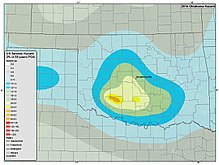
[67] Assessing the hazard potential for the Meers fault suffers from similar problems[48] but it is considered the largest seismic hazard source of the central United States[68] as it has the potential to cause large earthquakes[32] and earthquakes in the central United States usually affect much larger regions than those of the western United States.
[69] In particular, it indicates that the Mid-Continent is not free of earthquakes and that the absence of recent seismicity does not rule out the presence of active faults.