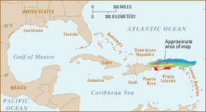
Puerto Rico Trench
[17] The island of Puerto Rico, which lies immediately to the south of the fault zone and the trench, suffered a destructive tsunami soon after the 1918 San Fermín earthquake.
Volcanic activity is frequent along the Lesser Antilles island arc southeast from Puerto Rico to the northern coast of South America.
Although originally part of a volcanic arc, the Virgin Islands, Puerto Rico, Hispaniola, Cuba, and Jamaica do not have active volcanoes.
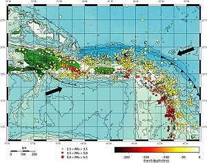
[19][20] According to NASA, beneath the trench is a mass so dense it deflects gravitational pull on the surface of the ocean, causing it to dip somewhat.
Following the 2004 tsunami that affected more than forty countries in the Indian Ocean, many more people now fear the consequences that such an event would bring to the Caribbean.
In the case of Puerto Rico and the U.S. Virgin Islands, the United States government has been studying the problem for years.
Puerto Rico has always been an area of concern to earthquake experts because, apart from the 1918 episode, there are frequent tremors in and around the island, indicating activity.
One soft dark individual, estimated to be 10–20 cm (3.9–7.9 in) long, has been identified by Dr. Stace E. Beaulieu of Woods Hole Oceanographic Institution as a sea cucumber, tentatively assigned to genus Peniagone.
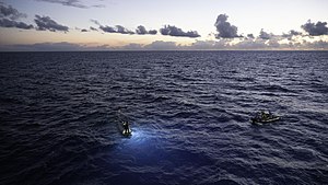
The American explorer Victor Vescovo dived to the deepest point of the Puerto Rico Trench and therefore the Atlantic Ocean on 19 December 2018, as part of the Five Deeps Expedition.
He reached a depth of 8,376 m (27,480 ft) ±5 m (16 ft) at 19°42'49" N, 67°18'39" W by direct CTD pressure measurements with the Deep-Submergence Vehicle DSV Limiting Factor (a Triton 36000/2 model submersible) and thus became the first person to reach the bottom of the Atlantic Ocean while also making the second-deepest recorded solo dive in history at that time.