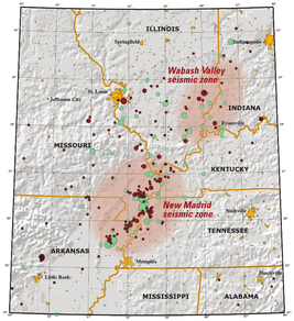
New Madrid seismic zone
[1] Earthquakes that occur in the New Madrid seismic zone potentially threaten parts of seven American states: Illinois, Missouri, Arkansas, Kentucky, Tennessee, and to a lesser extent Mississippi and Indiana.
[2] The 150-mile (240 km)-long seismic zone, which extends into five states, stretches southward from Cairo, Illinois; through Hayti, Caruthersville, and New Madrid in Missouri; through Blytheville into Marked Tree in Arkansas.
[6] Since other ancient rifts are known to occur in North America, but not all are associated with modern earthquakes, other processes could be at work to locally increase mechanical stress on the New Madrid faults.
[9][10] The zone had four of the largest earthquakes in recorded North American history, with moment magnitudes estimated to be as large as 7 or greater, all occurring within a 3-month period between December 1811 and February 1812.
As uplift rates associated with large New Madrid earthquakes could not have occurred continuously over geological timescales without dramatically altering the local topography, studies have concluded that the seismic activity there cannot have gone on for longer than 64,000 years, making the New Madrid seismic zone a young feature, or that earthquakes and the associated uplift migrate around the area over time, or that the NMSZ has short periods of activity interspersed with long periods of dormancy.
[13] About 80 kilometres (50 mi) southwest of the presently defined NMSZ, but close enough to be associated with the Reelfoot Rift, near Marianna, Arkansas, two sets of liquefaction features indicative of large earthquakes have been tentatively identified and dated to 3500 and 4800 BC.
As the tree ring record in Reelfoot Lake and the St. Francis sunk lands extend back to 1682 and 1321, respectively, Van Arsdale et al. interpret the lack of similar signals elsewhere in the chronology as evidence against large New Madrid earthquakes between those years and 1811.
The quake damaged virtually all the buildings in Charleston, created sand volcanoes by the city, cracked a pier on the Cairo Rail Bridge, and toppled chimneys in St. Louis, Missouri; Memphis, Tennessee; Gadsden, Alabama; and Evansville, Indiana.
[23] In 2008 in the nearby Wabash Valley seismic zone, a similar magnitude 5.4 earthquake occurred with its epicenter in Illinois near West Salem and Mount Carmel.
In a report filed in November 2008, the U.S. Federal Emergency Management Agency warns that a serious earthquake in the NMSZ could result in "the highest economic losses due to a natural disaster in the United States," further predicting "widespread and catastrophic" damage across Alabama, Arkansas, Illinois, Indiana, Kansas, Kentucky, Mississippi, Missouri, Oklahoma, Texas, and particularly Tennessee, where a 7.7 magnitude quake would cause damage to tens of thousands of structures affecting water distribution, transportation systems, and other vital infrastructure.
The potential for the recurrence of large earthquakes and their effects today on densely populated cities in and around the seismic zone has generated much research devoted to understanding the NMSZ.
By studying evidence of past quakes and closely monitoring ground motion and current earthquake activity, scientists attempt to understand their causes and recurrence intervals.
In October 2009, a team composed of University of Illinois and Virginia Tech researchers headed by Amr S. Elnashai, funded by the Federal Emergency Management Agency, considered a scenario where all three segments of the New Madrid fault ruptured simultaneously with a total earthquake magnitude of 7.7.