Cyclone Gwenda
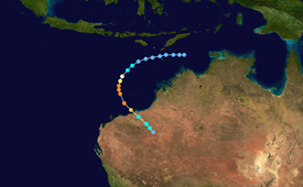
Forming out of a tropical disturbance over the Arafura Sea on 2 April 1999, the precursor to Gwenda tracked slowly westward and gradually became more organised.
It began to undergo explosive intensification the following day, and in a 30-hour span ending early on 7 April, the storm's maximum 10-minute sustained wind speed increased from 75 to 225 km/h (45 to 140 mph) and its barometric pressure decreased to 900 hPa (mbar).
Less than 18 hours after peaking, the storm made landfall roughly 45 km (28 mi) east of Port Hedland, Western Australia with winds of 100 km/h (60 mph).
Drifting westward, the system gradually became better organised, and early on 2 April, the Australian Bureau of Meteorology classified it as a tropical low.
[2][3] Over the following two days, the low continued to mature; on 4 April, the Bureau of Meteorology upgraded it to a Category 1 cyclone and named it Gwenda.
[2][3] Around the same time, the Joint Typhoon Warning Center (JTWC) issued a Tropical Cyclone Formation Alert as deep convection became concentrated around the centre of circulation and the system's outflow significantly improved.
[2] Its forward motion significantly decreased as it turned due south before curving towards the southeast,[2] and in a 30-hour span, maximum winds around the centre of the storm increased from 75 to 225 km/h (45 to 140 mph).
At the end of the intensification phase on 7 April, the Bureau of Meteorology classified the storm as a Category 5 cyclone, the third of the season, with a pressure of 900 hPa (mbar).
[3] The JTWC also reported a substantial increase in intensity, classifying Gwenda as a high-end Category 4 equivalent on the Saffir–Simpson hurricane scale with 1-minute sustained winds of 240 km/h (150 mph).
[6] Hours after attaining this intensity, increasing wind shear began to impact the cyclone, causing convection to become elongated and the eye less defined.
[4][5] Late on 7 April, the centre of Gwenda made landfall as a Category 2 cyclone roughly 45 km (28 mi) east of Port Hedland with winds of 100 km/h (60 mph).
[15][16] Shortly before the storm struck, Len Broadbridge, director of the Western Australia Bureau of Meteorology declared, "Port Hedland is now in grave danger.
Tropical storm (39–73 mph, 63–118 km/h)
Category 1 (74–95 mph, 119–153 km/h)
Category 2 (96–110 mph, 154–177 km/h)
Category 3 (111–129 mph, 178–208 km/h)
Category 4 (130–156 mph, 209–251 km/h)
Category 5 (≥157 mph, ≥252 km/h)
Unknown
