Cyclone Orson
[2] Forming out of a tropical low on 17 April 1989, Orson gradually intensified as it tracked towards the west.
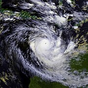
The following day, the cyclone reached its peak intensity with winds of 250 km/h (160 mph) (10-minute sustained) and a barometric pressure of 904 hPa (mbar).
Despite Orson's extreme intensity, damage was relatively minimal as it struck a sparsely populated region of Western Australia.
Cyclone Orson originated out of a tropical low, monitored by the Australian Bureau of Meteorology, that formed northwest of Darwin, Northern Territory on 17 April 1989.
The system tracked southwest throughout the day before turning due west and strengthening into a tropical cyclone, at which time it received the name Orson.
By this time, Orson began to turn towards the southwest and on 20 April,[3] the storm intensified into a Category 5 cyclone with winds of 210 km/h (130 mph) (10-minute sustained).
[5] It was later surpassed by Severe Tropical Cyclone Gwenda in 1999 when that storm attained a pressure of 900 hPa (mbar).
[2] The JTWC also reported that Orson had weakened, with winds at landfall estimated at 230 km/h (140 mph) 1-minute sustained).
[2] Continuing to accelerate to nearly 50 km/h (31 mph), the remnants of the storm moved over the Great Australian Bight late on 24 April.
[8][10] 905 hPa (26.72 inHg) As Cyclone Orson approached the coast of Western Australia, residents were urged to prepare for the storm; people proceeded to clean up litter, secure outdoor items and make sure their disaster kits were stocked.
[12] Since Cyclone Orson made landfall in a sparsely populated region, its effects were relatively light compared to its intensity.
[3] The North Rankin gas platform sustained minor damage despite wind gusts reaching 270 km/h (170 mph)[14] and waves estimated at 21 m (69 ft).
[16] After an assessment of damage, it was found that the drill rig snapped off and broke the chains of two anchors before drifting nearly 2 km (1.2 mi) from the platform.

Tropical storm (39–73 mph, 63–118 km/h)
Category 1 (74–95 mph, 119–153 km/h)
Category 2 (96–110 mph, 154–177 km/h)
Category 3 (111–129 mph, 178–208 km/h)
Category 4 (130–156 mph, 209–251 km/h)
Category 5 (≥157 mph, ≥252 km/h)
Unknown