Cyclone Helen (2007)
Late on 4 January, the storm made landfall near Channel Point with winds of 95 km/h (60 mph) though rapidly weakened to a tropical low within 12 hours.
From late December through 6 January, Helen and its precursor low produced significant rainfall over the Northern Territory, generally amounting between 100 and 200 mm (3.9 and 7.9 in).
As a tropical cyclone, Helen produced significant wind gusts across the Top End, peaking at 120 km/h (75 mph), downing thousands of trees.
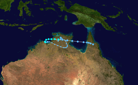
Following this, a strong Madden–Julian oscillation phase took shape, leading to the development of Tropical Cyclone Melanie off the coast of Western Australia and an area of low pressure over the Top End by 28 December.
Steadily strengthening, the low attained gale-force winds near its centre during the morning of 4 January and was subsequently named Helen by the Bureau of Meteorology.
Intensification continued up until landfall, by which time Helen had attained Category 2 status on the Australian tropical cyclone intensity scale.
Maximum ten-minute sustained winds reached 95 km/h (60 mph) and the storm's barometric pressure decreased to 975 mbar (hPa; 28.79 inHg).
As it moved ashore, the storm developed an eye; however, this feature began breaking apart once overland and the eyewall merged into the system's feeder bands.
Due to an increase in forward motion, the system was unable to regenerate sufficient convection to be reclassified a tropical cyclone before making a second landfall along the Cape York Peninsula.
[2] Starting in late December, widespread rains produced by the precursor to Helen prompted the issuance of flood warnings throughout the Top End region.
[5] By 6 January, warnings were issued for the western coast of the Cape York Peninsula between Karumba and Weipa as the remnants of Helen were forecast to regain storm intensity.
On 4 January, a car with three people was swept away by the river; two of the passengers managed to escape and swim to shore, but the third person remained trapped.
[1] Near Channel Point, the cyclone brought a storm surge of 2 to 3 m (6.6 to 9.8 ft), barely surpassing the highest astronomical tide in a few areas.
[16] Two days after the storm, 500 homes remained without electricity and frustrated residents were further angered after discovering that the Power and Water agency was in control of tree removal and not emergency services.
Tropical storm (39–73 mph, 63–118 km/h)
Category 1 (74–95 mph, 119–153 km/h)
Category 2 (96–110 mph, 154–177 km/h)
Category 3 (111–129 mph, 178–208 km/h)
Category 4 (130–156 mph, 209–251 km/h)
Category 5 (≥157 mph, ≥252 km/h)
Unknown

