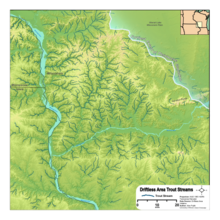
Driftless Area
The Driftless Area, also known as Bluff Country and the Paleozoic Plateau, is a topographic and cultural region in the Midwestern United States[1] that comprises southwestern Wisconsin, southeastern Minnesota, northeastern Iowa, and the extreme northwestern corner of Illinois.
The eastern section of the Driftless Area in Minnesota is called the Blufflands, due to the steep bluffs and cliffs around the river valleys.
Its landscape is characterized by steep hills, forested ridges, deeply carved river valleys, and karst geology with spring-fed waterfalls and cold-water trout streams.
[10] Another factor that may have contributed to the lack of glaciation of the Driftless area is the fractured, permeable bedrock within the Paleozoic Plateau underlying it, which would have promoted below-ground drainage of subglacial water that would otherwise have lubricated the underside of the glacial ice sheet.
Water erosion continued carving the existing gullies, ravines, stream beds, and river valleys ever deeper into the paleozoic plateau, following the original drainage patterns.
"[12] In the east, the Baraboo Range, an ancient, profoundly eroded monadnock in south central Wisconsin, consists primarily of Precambrian quartzite and rhyolite.
Due to the rapid movement of underground water through regions with karst topography, groundwater contamination is a major concern in the Driftless area.
As rivers and streams approach their confluence with the Mississippi, their canyons grow progressively steeper and deeper, particularly in the last 25 miles (40 km) in their journey to their mouths.
The change in elevation above sea level from ridgetops lining a stream to its confluence with the main-stem Mississippi can reach well past 650 feet (200 m) in only a few miles.
Small towns in a deep steep valley going down to the Mississippi are at risk every 50 to 100 years or so of a major flood, as with the wreck of Gays Mills, Wisconsin, in August 2007, or the holding of the levee in Houston, Minnesota, (on the South Fork Root River) at the same time.
[20] As home to the formation of a substantial portion of the gorge of the Upper Mississippi, this enormous quantity of sediment goes down at least 300 feet (91 m) under the present riverbottom at the confluence of the Wisconsin River.
Prairie was restricted primarily to the broader ridgetops, which were unfavorable sites for trees due to thin soils and shallow bedrock, rapid drainage, and desiccating winds; all these conditions were also good for carrying fires across the landscape.
Although evidence exists that mastodons inhabited mostly coniferous spruce forests associated with the taiga biome, it is likely that most or all of the Driftless Area was at times covered by tundra and permafrost during periods of glacial maximums.
[citation needed] Many farmers in the region use contour plowing, strip cropping, and other agricultural practices to reduce soil erosion due to the hilly terrain.
Soil erosion presents the Army Corps of Engineers with a problem that requires it to dredge the Mississippi River shipping channels to keep them open.
They are in adjoining areas of glacial till, drift, and in moraines; the region is extraordinarily well drained, and there is rarely a place where even a pond can naturally form.
[33] The bioregion's economic and cultural characteristics were federally recognized with the granting of the Upper Mississippi River Valley (UMRV) viticultural area, the largest designated winemaking region in the country, by the Treasury Division's Tax and Trade Bureau in 2009.
[35] The Driftless Region Food and Farm Project, in partnership with the University of Wisconsin-Madison Center for Integrated Agricultural Systems, is a coalition of sustainable-agriculture farmers, processors, distributors, chefs, planning commissions, and other participants.
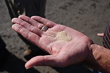
[37] The sandstone contains quartz (silica) sand grains of the ideal hardness, shape, and size for use in hydraulic fracturing by the petroleum and natural gas industries.
[41] Industry changes as of 2021[update] have caused Hi-Crush, Covia, and Superior Silica Sands—all with operations in Wisconsin—to liquidate their frac sand mines and declare bankruptcy.
"[44] The area includes all or part of Dakota, Goodhue, Rice, Wabasha, Winona, Olmsted, Dodge, Houston, Fillmore, and Mower Counties.
Additional communities include Red Wing, Lake City, Winona, La Crescent, Chatfield, Lanesboro, Rushford, Houston, and Caledonia.
The region is characterized "by the absence of glacial drift deposits, the sculpted topography, and the presence of the ancient limestone immediately beneath the soil and in cliff outcroppings.
The steep ridges, numerous rock outcroppings, and deep, narrow valleys in the Driftless Area are in marked contrast with the rest of the state, where glaciers have modified the landscape.
The Driftless Area is located in all or part of Pierce, Pepin, Dunn, Eau Claire, Buffalo, Trempealeau, Jackson, La Crosse, Monroe, Juneau, Vernon, Richland, Sauk, Crawford, Iowa, Dane, Green, Grant, and Lafayette counties.
The U.S. Army maintains a presence at Fort McCoy in Monroe County between Sparta and Tomah, immediately south of the Black River State Forest.
Plans for a large reservoir on the Kickapoo River at La Farge, Wisconsin were dropped in 1975 after much controversy due to cost-benefit and environmental concerns.
Due to its great depth, vertical underwater cliffs, clear water, and submerged mining features, the lake is popular with scuba divers.
Early miners often lived in the mine tunnels, leading outsiders to compare them to the burrowing badger, a nickname that eventually came to be used for all Wisconsin residents.
The mouth of this river, near Hanover adjacent to the former Savanna Army Depot, comes close to the southern end of the Driftless Area on the eastern side of the Mississippi (see Lock and Dam No.