Epirus
Epirus became part of the semi-independent Pashalik governed by the Ottoman Albanian ruler Ali Pasha in the early 19th century, but the Sublime Porte re-asserted its control in 1821.
[15] By the early 1st millennium BC, all fourteen Epirote tribes including the Chaonians in northwestern Epirus, the Molossians in the centre and the Thesprotians in the south, were speakers of a strong west Greek dialect.
[27][28] Beginning in 370 BC, the Molossian Aeacidae dynasty built a centralized state in Epirus and began expanding their power at the expense of rival tribes.
[1] The Aeacid dynasty ended in 232 BC, but Epirus remained a substantial power, unified under the auspices of the Epirote League as a federal state with its own parliament, or synedrion.
The new province extended from the Gulf of Aulon (Vlorë) and the Acroceraunian Mountains in the north to the lower course of the Acheloos River in the south, and included the northern Ionian Islands of Corfu, Lefkada, Ithaca, Cephallonia, and Zakynthos.
[32] In the 4th century, Epirus was still a stronghold of paganism, and was aided by Emperor Julian (r. 361–363) and his praetorian prefect Claudius Mamertinus through reduction in taxes and the rebuilding of the provincial capital, Nicopolis.
The Vandals notably seized Nicopolis in 474 as a bargaining chip in their negotiations with Emperor Zeno, and plundered Zakynthos, killing many of its inhabitants and ferrying off others into slavery.
[35] Procopius further reports that in 551, in an attempt to interdict the Byzantines' lines of communication with Italy during the Gothic War, the Ostrogoth king Totila sent his fleet to raid the shores of Epirus.
[36] In response to these raids, and to repair the damage done by two destructive earthquakes in 522, Justinian initiated a wide-ranging programme of reconstruction and re-fortification: Hadrianopolis was rebuilt, albeit in reduced extent, and renamed Justinianopolis, while Euroea was moved further inland (traditionally identified with the founding of Ioannina), while Procopius claims that no less than 36 smaller fortresses in Epirus Vetus—most of them not identifiable today—were either rebuilt or built anew.
[39] Slavic toponyms are nearly lacking in the mountains of Labëria (on the Kurvelesh plateau), in the Ionian coast where today Lab Albanian villages neighbour with the Greek-speaking ones, therefore it can be assumed that the expansion of the Slavs had not reach this region.
[40] As in eastern Greece, the restoration of Byzantine rule seems to have proceeded from the islands, chiefly Cephallonia, which was certainly under firm Imperial control in c. 702, when Philippicus Bardanes was banished there.
[43] Following the great naval victory of admiral Nasar in 880, and the beginning of the Byzantine offensive against the Arabs in southern Italy in the 880s, the security situation improved and the Theme of Nicopolis was established, most likely after 886.
As the authors of the Tabula Imperii Byzantini comment, it appears that "the Byzantine administration had brought the strongly Slavic-settled areas in the mainland somewhat under its control, and a certain Re-Hellenization had set in".
[48] This is evidenced from the fact that the territories that were under Bulgarian rule formed part of the autocephalous Archbishopric of Ohrid after the Byzantine conquest of Bulgaria by Emperor Basil II in 1018: thus in Epirus the sees of Chimara, Hadrianopolis, Bela, Buthrotum, Ioannina, Kozyle, and Rogoi passed under the jurisdiction of Ohrid, while the Metropolitan of Naupaktos retained only the sees of Bonditza, Aetos, and Acheloos.
[50] When Constantinople fell to the Fourth Crusade in 1204, the partitio Romaniae assigned Epirus to Venice, but the Venetians were largely unable to effectively establish their authority, except over Dyrrhachium (the "Duchy of Durazzo").
The Greek noble Michael Komnenos Doukas, who had married the daughter of a local magnate, took advantage of this, and within a few years consolidated his control over most of Epirus, first as a Venetian vassal and eventually as an independent ruler.
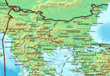
[53][54] During this time, the definition of Epirus came to encompass the entire coastal region from the Ambracian Gulf to Dyrrhachium, and the hinterland to the west up to the highest peaks of the Pindus mountain range.
Kosta Giakoumis believes that the use of hypothetical immigrations to explain the accounts of Albanian presence in Epirote territory prior to the 13th-14th century is somewhat arbitrary.
[57] The Byzantine authorities in Constantinople soon re-established a measure of control by making the Despotate of Epirus a vassal state, but Albanian clans proceeded to invade and seize most of the region.
[66] Carlo I Tocco (1411–1429) then assumed control of Ioannina, commencing heavy conflicts with Jakob and Muriq Shpata, the Albanian leaders of the Despotate of Arta.
[69] Nevertheless, internal dissension eased the Ottoman conquest, which began with the capture of Ioannina in 1430 and continued with Arta in 1449, Angelokastro in 1460, Riniasa Castle and its environs (in what is now Preveza) in 1463,[70] and finally Vonitsa in 1479.
In the 18th century, as the power of the Ottoman Empire declined, Epirus became a de facto independent region under the despotic rule of Ali Pasha of Tepelena, a Muslim Albanian brigand who rose to become the provincial governor of Ioannina in 1788.
[1] At the height of his power, he controlled all of Epirus, and much of the Peloponnese, central Greece, and parts of western Macedonia[1] Ali Pasha's campaign to subjugate the confederation of the settlements of Souli met with fierce resistance by the Souliot warriors of the mountainous area.
Two of the founding members of the Filiki Eteria (the secret society of the Greek revolutionaries), Nikolaos Skoufas and Athanasios Tsakalov, came from the Arta area and the city of Ioannina, respectively.
[79] Throughout, the late period of Ottoman rule (from the 18th century) Greek and Aromanian population of the region suffered from Albanians raiders, that sporadically continued after Ali Pasha's death, until 1912–1913.
[86] After fierce guerrilla fighting, they managed to gain full autonomy under the terms of the Protocol of Corfu, signed by Albanian and Northern Epirote representatives and approved by the Great Powers.
[87] The Republic, however, was short-lived, as when World War I broke out, Albania collapsed, and northern Epirus was alternately controlled by Greece, Italy and France at various intervals.
Due to the extensive activity of the anti-Nazi Greek resistance (mainly under EDES), the Germans carried out large scaled anti-partisan sweeps, making wide use of Nazi-collaborationist bands of Cham Albanians, who committed numerous atrocities against the civilian population.
Another reason for the continuation of the state of war until 1987 was that during the entire period of Communist rule in Albania, the Greek population of Northern Epirus experienced forced Albanisation.
[85] Relations began to improve in the 1980s with Greece's abandonment of any territorial claims over Northern Epirus and the lifting of the official state of war between the two countries.


Red dotted line : Territory of Autonomous State of Northern Epirus
