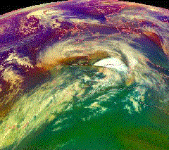
European windstorm
[1] Deep areas of low pressure are common over the North Atlantic, and occasionally start as nor'easters off the New England coast.
The countries most commonly affected include the United Kingdom, Ireland, the Netherlands, Norway, Germany, the Faroe Islands and Iceland.
These phenomena vary in terms of physical mechanisms, atmospheric structure, spatial extent, duration, severity level, predictability and location relative to cyclone and fronts.
[4] The state of the North Atlantic Oscillation relates strongly to the frequency, intensity, and tracks of European windstorms.
[8] A connection between wintertime cold air outbreaks in North America and European windstorms has been hypothesized in the last years.[when?
[13][14] In November 2011, Cyclone Berit moved across Northern Europe, and just a day later another storm, named Yoda, hit the same area.
For instance, the Norwegian weather service also names independently notable storms that affect Norway,[16] which can result in multiple names being used in different countries they affect, such as: In 2011, a social media campaign resulted in the storm officially called Cyclone Friedhelm being widely referred to as Hurricane Bawbag[17][18][19] and Hurricane Fannybaws.
[25][circular reference] During 1954, Karla Wege, a student at the Free University of Berlin's meteorological institute suggested that names should be assigned to all areas of low and high pressure that influenced the weather of Central Europe.
[27] However, the order was leaked to the German press agency, Deutsche Presse-Agentur, who ran it as its lead weather story.
[27] Germany's ZDF television channel subsequently ran a phone in poll on 17 July 1991 and claimed that 72% of the 40,000 responses favored keeping the names.
[26] In November 2002 the "Adopt-a-Vortex" scheme began, which allows members of the public or companies to buy naming rights for a letter chosen by the buyer that are then assigned alphabetically to high and low pressure areas in Europe during each year.
Likewise the use of the French term ouragan is similarly discouraged as hurricane is in English, as it is typically reserved for tropical storms only.
The name European windstorm reflects that these storms in Europe are primarily notable for their strong winds and associated damage, which can span several nations on the continent.
[36] The current definition of severe gales (which warrants the issue of a weather warning) are repeated gusts of 70 mph (110 km/h) or more over inland areas.
[41] European windstorms wipe out electrical generation capacity across large areas, making supplementation from abroad difficult (windturbines shut down to avoid damage and nuclear capacity may shut if cooling water is contaminated or flooding of the power plant occurs).
Transmission capabilities can also be severely limited if power lines are brought down by snow, ice or high winds.
[53] Also following Storm Angus the UK's National Grid launched an investigation into whether a ship's anchor damaged four of the eight cables of the Cross Channel high voltage interconnector, which would leave it only able to operate at half of its capacity until February 2017.