Geographical exploration
[clarification needed] The first, covering most of Homo sapiens history, saw humans moving out of Africa, settling in new lands, and developing distinct cultures in relative isolation.
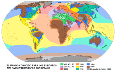
The first modern atlas was the Theatrum Orbis Terrarum, published by Abraham Ortelius, which included a world map that depicted all of Earth's continents.
According to Virgil's Aeneid and other ancient sources, the legendary Queen Dido was a Phoenician from Tyre who sailed to North Africa and founded the city of Carthage.
Only the one conducted by emperor Nero seemed to be a preparative for the conquest of Ethiopia or Nubia; in 62 AD, two legionaries explored the sources of the Nile.
[6] One of the main objectives of the explorations was to locate and obtain gold, using camels to transport it overland back to Roman provinces on the Mediterranean coast.
[7] The explorations near the African western and eastern coasts were supported by Roman ships and deeply related to the naval commerce (mainly toward the Indian Ocean).
[8] When Zhang returned to China in 125 BC, he reported on his visits to Dayuan (Fergana), Kangju (Sogdia), and Daxia (Bactria, formerly the Greco-Bactrian Kingdom which had just been subjugated by the Da Yuezhi).
[9] Zhang described Dayuan and Daxia as agricultural and urban countries like China, and although he did not venture there, described Shendu (the Indus River valley of Northwestern India) and Anxi (Parthian territories) further west.
The key invention to their exploration was the outrigger canoe, which provided a swift and stable platform for carrying goods and people.
Mathematical modelling based on DNA genome studies, using state of the art techniques, have shown that a large number of Polynesian migrants (100–200), including women, arrived in New Zealand around the same time, in about 1280.
Otago University studies have tried to link distinctive DNA teeth patterns, which show special dietary influence, with places in or nearby the Society Islands.
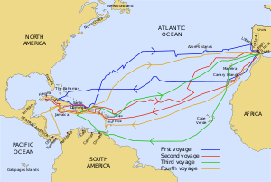
Explorers of routes from Europe towards Asia, the Indian Ocean, and the Pacific Ocean, include Vasco da Gama (1460–1524), a navigator who made the first trip from Europe to India and back by the Cape of Good Hope, discovering the ocean route to the East; Pedro Álvares Cabral (1467/1468–1520), who, following the path of Vasco da Gama, claimed Brazil and led the first expedition that linked Europe, Africa, America, and Asia; Diogo Dias, who discovered the eastern coast of Madagascar and rounded the corner of Africa; explorers such as Diogo Fernandes Pereira and Pedro Mascarenhas (1470–1555), among others, who discovered and mapped the Mascarene Islands and other archipelagos.
?–1527), who explored the territories of present-day southern Brazil, Paraguay and Bolivia, crossing the Chaco and reaching the Andes (near Sucre).
Álvar Núñez Cabeza de Vaca (1490–1558) discovered the Mississippi River and was the first European to sail the Gulf of Mexico and cross Texas.
In 1818, the British researcher John Ross was the first to find that the deep sea is inhabited by life when catching jellyfish and worms in about 2,000 m (6,562 ft) depth with a special device.
In the 20th century, deep-sea exploration advanced considerably through a series of technological inventions, ranging from the sonar system, which can detect the presence of solid objects underwater through the use of reflected sound, to manned deep-diving submersibles.
In 1960, Jacques Piccard and United States Navy Lieutenant Donald Walsh descended in the bathyscaphe Trieste into the deepest part of the world's oceans, the Mariana Trench.
Both of the Voyager probes have left the Solar System, bearing imprinted gold discs with multiple data types.