Geography of Bangladesh
Bangladesh is a densely populated, low-lying, mainly riverine country located in South Asia with a coastline of 580 km (360 mi) on the northern littoral of the Bay of Bengal.
Exports of garments and shrimp plus remittances from Bangladeshis working abroad provide the country's three main sources of foreign exchange income.
The physical geography of Bangladesh is varied and has an area characterised by two distinctive features: a broad deltaic plain subject to frequent flooding, and a small hilly region crossed by swiftly flowing rivers.
On the south is a highly irregular deltaic coastline of about 580 kilometres (360 mi), fissured by many rivers and streams flowing into the Bay of Bengal.
Saka Haphong Mountain is the highest peak in Bangladesh with an elevation of 1,052 metres (3,451 ft), located in the south-eastern part of the hills.
A variety of wild animals are found in the forest areas, such as in the Sundarbans on the southwest coast, which is the home of the Royal Bengal tiger.
The alluvial soils in the Bangladesh Plain are generally fertile and are enriched with heavy silt deposits carried downstream during the rainy season.
Urbanisation is proceeding rapidly, and it is estimated that only 30% of the population entering the labour force in the future will be absorbed into agriculture, although many will likely find other kinds of work in rural areas.
The Sundarbans, an area of coastal tropical jungle in the southwest and last wild home of the Bengal tiger, and the Chittagong Hill Tracts on the south-eastern border with Myanmar and India, are the least densely populated.
From March to May, violent thunderstorms, called northwesters by local English speakers, produce winds of up to 60 kilometres per hour (37.3 mph).
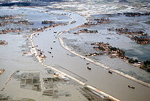
During the intense storms of the early summer and late monsoon season, southerly winds of more than 160 kilometres per hour (99.4 mph) cause waves to crest as high as 6 metres (19.7 ft) in the Bay of Bengal, which brings disastrous flooding to coastal areas.Heavy rainfall is characteristic of Bangladesh, causing it to flood every year.
Because of its location just south of the foothills of the Himalayas, where monsoon winds turn west and northwest, the region of Sylhet in northeastern Bangladesh receives the greatest average precipitation.
Average daily humidity ranged from March lows of between 55 and 81% to July highs of between 94 and 100%, based on readings taken at selected stations nationwide in 1986.
The other travels up the Bay of Bengal and over eastern India and Bangladesh, crossing the plain to the north and northeast before being turned to the west and northwest by the foothills of the Himalayas.
Annual monsoon flooding results in the loss of human life, damage to property and communication systems, and a shortage of drinking water, which leads to the spread of disease.
There are no precautions against cyclones and tidal bores except giving advance warning and providing safe public buildings where people may take shelter.
Efforts by the government under the Third Five-Year Plan (1985–90) were directed toward accurate and timely forecast capability through agrometeorology, marine meteorology, oceanography, hydrometeorology, and seismology.
[21] Bangladesh's vulnerability to the effects of climate change is due to a combination of geographical factors, such as its flat, low-lying, and delta-exposed topography.
Flooding of the rivers during the monsoon season causes enormous hardship and hinders development, but fresh deposits of rich silt replenish the fertile but overworked soil.
Originating as the Yarlung Tsangpo River in China's Xizang Autonomous Region (Tibet) and flowing through India's state of Arunachal Pradesh, where it becomes known as the Brahmaputra ("Son of Brahma"), it receives waters from five major tributaries that total some 740 kilometres (460 mi) in length.
This mighty network of four river systems flowing through the Bangladesh Plain drains an area of some 1.5 million square kilometres (580,000 sq mi).
The numerous channels of the Padma-Meghna, its distributaries, and smaller parallel rivers that flow into the Bay of Bengal are referred to as the Mouths of the Ganges.
Despite severe resource constraints, the Government of Bangladesh has made it a policy to try to bring additional areas under irrigation without salinity intrusion.
The main rivers of Bangladesh derived from the Himalayas carry a high level of sediment and deposit it across the Bay of Bengal.
The island reformation tendency showed that the new land area increased every year by an average of 20 km2 (0.038) along the coastal region of Bangladesh.
[30] The analysis showed that the tidal flats of the Meghna River estuary have undergone considerable geomorphological change over a 33-year period, from 1984 to 2016, now only occurring in 17.1% of their initial extent despite expanding in area by 20.6%.