Geography of Newfoundland and Labrador
[2] Labrador is the easternmost part of the Canadian Shield, a vast area of ancient metamorphic rock comprising much of northeastern North America.
Gros Morne National Park has a reputation of being an outstanding example of tectonics at work,[3] and as such has been designated a World Heritage Site.
[1] The fauna of Labrador is typical of that of similar areas of North America while the island of Newfoundland has considerably fewer mammals and no native amphibians.
About half of the province's economy is based on its abundant natural resources, notably petroleum, minerals, forestry and the fishery.
[1] Major bays, peninsulas, river systems and mountain ranges are typically oriented southwest to northeast, parallel to the Appalachians.
Along the west coast lie the Long Range Mountains, which are formed by an elongated block of the Earth's crust (a horst) which rises to about 600 metres (2,000 ft) above sea level.
The main plateau of the central part of the island, which was once the sea bottom of the ancient Iapetus Ocean,[1] has been heavily eroded by water and ice.
Steep, solitary rock knobs, called "tolts" in Newfoundland (elsewhere known as inselbergs or monadnocks), which jut 100 metres (330 ft) or more above the generally flat terrain are the remnants of a former higher landscape level.
[13] The long narrow lakes of the west coast, notably those in Gros Morne National Park resulted from glacial erosion.
They are only found on a narrow strip of land extending approximately 150 kilometres (93 mi) on the extreme western portion of the Great Northern Peninsula, a limestones barrens habitat.
[25] Moose, snowshoe hare, American red squirrel, eastern chipmunk, and masked shrew, and others, were brought to the island through specific wildlife mandates.
An unusual experiment conducted in 1964 involved relocating a small herd of bison onto Brunette Island in Fortune Bay.
[20] The deeper waters are home to a variety of fish, such as Atlantic cod, sculpins and cunners, halibut, haddock, sharks, and marine mammals, such as dolphins, porpoises, and whales.
[20] The taiga is dominated by coniferous trees, notably balsam fir and black spruce, though the deciduous white birch, trembling aspen and mountain ash are also present.
[20] Willow ptarmigan, common raven, and blackpoll warbler inhabit the forests of southern Labrador while golden eagles, rough-legged hawks and peregrine falcons nest on steep cliffs.
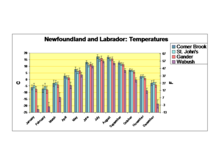
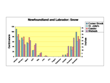
Weather systems affecting Newfoundland usually originate from the west, over mainland Canada, or from the southwest, from the east coast of the United States.
Cyclonic storms consist of an area of low atmospheric pressure characterized by inward spiraling winds that rotate counter clockwise in the Northern Hemisphere.
Such storms passing to the south of the island bring strong northeasterly winds sweeping in off the open North Atlantic Ocean.
[34] During a violent storm on February 15, 1982, the drilling rig Ocean Ranger capsized and sank on the Grand Banks, 300 kilometres (190 mi) east of St.
[34] Shallow soil and bedrock deeply scored by glaciers are responsible for the numerous lakes and ponds, and short, swift flowing rivers scattered across Newfoundland and Labrador.
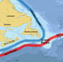
The Strait of Belle Isle connects the Gulf of St. Lawrence with the Labrador Sea and is the narrowest channel separating Newfoundland from mainland Canada.
[34] The Grand Banks are an area of significant petroleum production with Hibernia, White Rose and Terra Nova oil fields all located there.
[38] Approximately 40,000 medium to large icebergs annually calve from Greenland glaciers, and depending on wind, and air and water temperature, between 400 and 800 of these go as far south as 48° north latitude (St.
[38] These icebergs represent a significant threat to shipping and off-shore oil platforms[39] and the hazard is aggravated by dense fog in this area.
While some of the pack ice off the west coast also comes from the sea off Labrador via the Strait of Belle Isle, most of it originates in the Gulf of St. Lawrence.
The leading edge of the pack ice is known as "The Front" and is important to the annual seal hunt off Newfoundland's north coast.
[6] Aquaculture is a new industry for the province, which in 2006 produced over 10,000 tonnes of Atlantic Salmon, mussels and Steelhead Trout worth over $50 million.
The oldest known European contact was made over a thousand years ago when the Vikings briefly settled in L'Anse aux Meadows.
Five hundred years later, European explorers (John Cabot, Gaspar Corte-Real, Jacques Cartier and others), fishermen from England, Portugal, France and Spain and Basque whalers (the remains of several whaling stations have been found at Red Bay, Newfoundland and Labrador) began exploration and exploitation of the area.
[48] Settlement of Labrador followed a similar pattern, with the interior being settled only in the latter part of the 20th century with the development of the iron ore mines at Wabush, hydroelectric generation at Churchill Falls and the military base at Goose Bay.