Geography of Quebec
[citation needed] More than 90% of Quebec's area lies within the Canadian Shield, and includes the greater part of the Labrador Peninsula.
The addition of parts of the vast and scarcely populated District of Ungava of the Northwest Territories between 1898 and 1912 gave the province its current form.
The territory of Quebec is extremely rich in resources in its coniferous forests, lakes, and rivers—pulp and paper, lumber, and hydroelectricity are still some of the province's most important industries.
[4] Quebec's highest point at 1,652 m (5,420 ft) is Mont d'Iberville, known in English as Mount Caubvick, located on the border with Newfoundland and Labrador in the northeastern part of the province, in the Torngat Mountains.
It extends northeastward from the southwestern portion of the province along the shores of the Saint Lawrence River to the Quebec City region, limited to the North by the Laurentian Mountains and to the South by the Appalachians.
It mainly covers the areas of the Centre-du-Québec, Laval, Montérégie and Montreal, the southern regions of the Capitale-Nationale, Lanaudière, Laurentides, Mauricie.
[9] Its landscape is low-lying and flat, except for isolated igneous outcrops near Montreal called the Monteregian Hills, formerly covered by the waters of Lake Champlain.
Geologically, the lowlands formed as a rift valley about 100 million years ago and are prone to infrequent but significant earthquakes.
[2] The most recent sedimentary rock layerswere formed as the seabed of the ancient Champlain Sea at the end of the last ice age about 14,000 years ago.
The rural part of the landscape is divided into narrow rectangular tracts of land that extend from the river and date back to settlement patterns in 17th century New France.
Although the area is inhabited principally by the Cree, Naskapi, and Innu First Nations, thousands of temporary workers reside at Radisson to service the massive James Bay Hydroelectric Project on the La Grande and Eastmain rivers.
The largest inland body of water is the Caniapiscau Reservoir, created in the realization of the James Bay Project to produce hydroelectric power.
Its access to the Atlantic Ocean and the interior of North America made it the base of early French exploration and settlement in the 17th and 18th centuries.
Northeast of Quebec City, the river broadens into the world's largest estuary, the feeding site of numerous species of whales, fish, and seabirds.
Other notable rivers include the Ashuapmushuan, Chaudière, Gatineau, Manicouagan, Ottawa, Richelieu, Rupert, Saguenay, Saint-François, and Saint-Maurice.
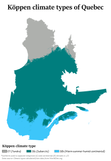
[17] Winters are long, very cold, and snowy, and among the coldest in eastern Canada, while summers are warm but very short due to the higher latitude and the greater influence of Arctic air masses.
[23][24] In periods of intense heat and cold, temperatures can reach 35 °C (95 °F) in the summer[25] and −40 °C (−40 °F) during the Quebec winter,[25] They may vary depending on the Humidex or Wind chill.
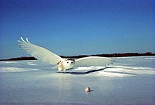
The birdlife is diverse including wild turkey (Meleagris gallopavo),[56] yellow-bellied sapsucker (Sphyrapicus varius) and loggerhead shrike (Lanius ludovicianus).
The small animals seen most commonly include the eastern grey squirrel, the snowshoe hare, the groundhog, the skunk, the raccoon, the chipmunk and the Canadian beaver.
[58] Inland waters are populated by small to large fresh water fish, such as the largemouth bass, the American pickerel, the walleye, the Acipenser oxyrinchus, the muskellunge, the Atlantic cod, the Arctic char, the brook trout, the Microgadus tomcod (tomcod), the Atlantic salmon, the rainbow trout, etc.
Sea and semi-aquatic birds seen in Quebec are mostly the Canada goose, the double-crested cormorant, the northern gannet, the American herring gull, the great blue heron, the sandhill crane, the Atlantic puffin and the common loon.
[11] On the edge of the Ungava Bay and Hudson Strait is the tundra, whose flora is limited to a low vegetation of lichen with only less than 50 growing days a year.
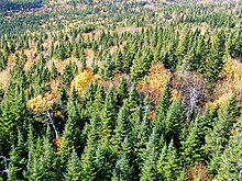
Not as arid as the tundra, the taiga is associated with the sub-Arctic regions of the Canadian Shield[67] and is characterized by a greater number of both plant (600) and animal (206) species, many of which live there all year.
By virtue of its transient nature, this area contains a diversity of habitats resulting in large numbers of plant (1000) and vertebrate (350) species, despite relatively cool temperatures.
Because of its climate (average annual temperature of 7 °C [45 °F]), it is in this area that one finds the greatest diversity of species, including more than 1600 vascular plants and 440 vertebrates.
Its relatively long growing season lasts almost 200 days and its fertile soils make it the centre of agricultural activity and therefore of urbanization of Quebec.
The distribution areas of the paper birch, the trembling aspen and the mountain ash cover more than half of Quebec territory.