Geography of North America
The continent is delimited on the southeast by most geographers at the Darién watershed along the Colombia-Panama border, placing all of Panama within North America.
Climate is determined to a large extent by the latitude, ranging from Arctic cold in the north to tropical heat in the south.
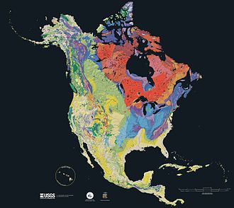
Seventy percent of North America is underlain by the Laurentia craton,[5] which is exposed as the Canadian Shield in much of central and eastern Canada around the Hudson Bay, and as far south as the U.S. states of Michigan, Wisconsin, and Minnesota.
This core has been enlarged by plate tectonics, most notably between 1.8 and 1.65 Ga when a piece currently stretching from Arizona to Missouri fused with the south and west portion of the craton.
[8] Periodic flooding by inland seas, most recently the Western Interior Seaway during the Cretaceous, caused the layer of sedimentary rock over the remainder of the craton.
"[10] The last glacial period of the current ice age caused a lowering of the sea level, exposing the Bering Land Bridge between Alaska and Siberia, which resulted in human migration from Asia to the Americas between 40,000 and 15,000 years ago.
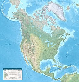
North America may be divided into at least five major physiographic regions:[citation needed] The Coastal Plain and the main belts of the North American Cordillera continue in the south in Mexico (where the Mexican Plateau, bordered by the Sierra Madre Oriental and the Sierra Madre Occidental, is considered a continuation of the intermontane system) to connect the Transverse Volcanic Range, a zone of high and active volcanic peaks south of Mexico City.
[15] Earlier placements in 1931 involved geographers balancing a cardboard cutout of a region on a needlelike point to find its center to establish a spot "6 miles west of Balta, Pierce County, North Dakota",[14] at 48⁰ 10′north, 100⁰ 10′west.
[16] In 1932, a field stone cairn recognizing this was erected in nearby Rugby, North Dakota at the intersections of U.S. Route 2 and ND State Highway 3.
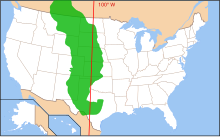
[17][18][19] The Great Plains is the broad expanse of prairie and steppe which lies east of the Rocky Mountains in the United States and Canada.
The narrow plains in the Mexican coast and the savannas of the Mississippi are analogous to, respectively, the Patagonian Steppes and the pampas of the Piranha, Paraguay, and Rio de la Plata.
Coniferous trees, including spruces, pines, hemlocks, and firs, are indigenous to the Canadian and Western U.S. mountain ranges as far south as San Francisco.
The Sierra Nevada and Cascade mountain ranges run along the entire Pacific Coast, acting as a barrier to the humid winds that sweep in from the ocean.
The rising topography forces this air upwards, causing moisture to condense and fall in the form of rain on the western slopes of the mountains, with some areas receiving more than 70 inches (1.8 m) of rainfall per year.
What precipitation does fall generally does not last long, lost primarily to evaporation, as well as rapid runoff and efficient water uptake and storage by native vegetation.
Three species of bear, several subspecies of wolf, and various other carnivores such as raccoons, skunks, and cats including cougars and lynxes are widely distributed.