Geography of the Democratic Republic of the Congo
The Democratic Republic of the Congo is the largest country of sub-Saharan Africa, occupying some 2,344,858 square kilometres (905,355 sq mi).
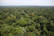
[1] The vast, low-lying central area is a plateau-shaped basin sloping toward the west, covered by tropical rainforest and criss-crossed by rivers.
High mountains of the Ruwenzori Range (some above 5,000 m or 16,000 ft) are found on the eastern borders with Rwanda and Uganda (see Albertine Rift montane forests for a description of this area).
[1] Having an average elevation of about 44 metres (144 ft), it measures roughly 800,000 square kilometres (310,000 sq mi), constituting about a third of the DRC's territory.
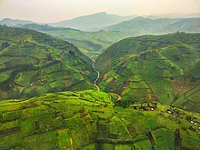
[1] North and south of the basin lie higher plains and, occasionally, hills covered with varying mixtures of savanna grasses and woodlands.
[1] The westernmost section of the DRC, a partly forested panhandle reaching the Atlantic Ocean,[2] is an extension of the southern uplands that drops sharply to a very narrow shore about 40 kilometres (25 mi) long.
[1] The eastern border of the DRC extends through the valley and its system of lakes, which are separated from each other by plains situated between high mountain ranges.
[1] The Congo River and its tributaries drain this basin and provide the country with the most extensive network of navigable waterways in Africa.
[1] The highest and least variable temperatures are to be found in the equatorial forest, where daytime highs range between 30 and 35 °C (86 and 95 °F), and nighttime lows rarely go below 20 °C (68 °F).
[1] Annual rainfall is highest in the heart of the Congo River basin and in the highlands west of Bukavu and with some variation tends to diminish in direct relation to distance from these areas.
[8] The majority of these emissions arise from land use change and deforestation, as the country uses little fossil fuels and only one-fifth of the population has access to electricity.
Elevation extremes: lowest point: Atlantic Ocean 0 m highest point: Pic Marguerite on Mont Ngaliema (Mount Stanley) 5,110 m Natural resources: cobalt, copper, niobium, petroleum, industrial and gem diamonds, gold, silver, zinc, manganese, tin, uranium, coal, hydropower, timber Land use: arable land: 3.09% permanent crops: 0.36% 96.55 (2012 est.)
Irrigated land: 105 km2 (2003) Total renewable water resources: 1,283 km3 (2011) total: 0.68 km3/yr (68%/21%/11%) per capita: 11.25 m3/yr (2005) Natural hazards Periodic droughts in south; Congo River floods (seasonal); in the east, in the Albertine Rift, there are active volcanoes Poaching threatens wildlife populations (for example, the painted hunting dog, Lycaon pictus, is now considered extirpated from the Congo[15] due to human overpopulation and poaching); water pollution; deforestation (chiefly due to land conversion to agriculture by indigenous farmers[16]); refugees responsible for significant deforestation, soil erosion, and wildlife poaching; mining of minerals (coltan — a mineral used in creating capacitors, diamonds, and gold) causing environmental damage party to: Biodiversity, Desertification, Endangered Species, Hazardous Wastes, Law of the Sea, Marine Dumping, Nuclear Test Ban, Ozone Layer Protection, Tropical Timber 83, Tropical Timber 94, Wetlands signed, but not ratified: Environmental Modification This is a list of the extreme points of the Democratic Republic of the Congo, the points that are farther north, south, east or west than any other location.