Geography of South Africa
The central plateau (apart from the Lesotho Highlands) forms a largely flat, tilted surface which, as indicated above, is highest in the east, sloping gently downwards to the west (at about 1,000 m above sea level).
Agriculture, which includes viniculture and fruit-growing, therefore depends on irrigation from rivers with sources in the mountains, which are frequently covered in snow during winter.
The Central Plateau is divided into several distinctly different regions (though with very vague boundaries), largely as a result of the rainfall distribution across South Africa: wet in the east and increasingly drier and more arid in the west.
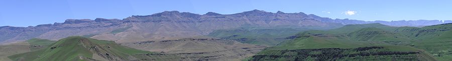
Its southern boundary is often taken to be the Orange River, from where the continuation of the plateau is known as the Great Karoo, except for a small strip just south of Lesotho which is often included in the Highveld.
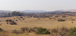
Much of the area is devoted to commercial farming, but it also contains South Africa's largest conurbation in Gauteng Province, the centre of the gold mining industry.
This southern limb of the Lowveld is bounded by South Africa's border with Mozambique to the east, and the north-eastern part of the Drakensberg to the west.
Before the middle of the 20th century, the Lowveld was also home to the tsetse fly, which transmits sleeping sickness to humans and nagana to animals, especially the horses of the travelers trying to reach the Highveld and Witwatersrand Gold Fields from Maputo.
This wildlife is particularly concentrated in the Kruger National Park located in the eastern Lowveld areas of Mpumalanga and Limpopo Provinces, along almost the entire border with Mozambique.
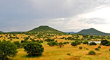
The Lowveld partly overlaps with a dry savanna ecoregion known as the Bushveld, a basin characterized by open grasslands with scattered trees and bushes.
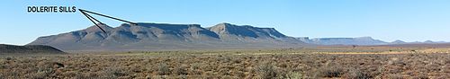
The town of Sutherland is located in the Roggeveld region of the Upper Karoo, with midwinter temperatures as low as −15 °C, and is thought to be the coldest inhabited place in South Africa.
The lowland region along the Indian Ocean coast is extremely narrow in the south, widening in the northern part of the province, while the central Natal Midlands consist of an undulating hilly, 1,000 m high plateau, rising to 1,500 m towards the west, at the foot of the Great Escarpment.
The coastal regions are typically covered with subtropical thickets, while the deeper ravines and steep slopes of the river valleys host Afromontane Forest.
The temperature in Ladysmith, further inland, in the Tugela River Valley, reaches 30 °C in the summer, but may drop below freezing point on winter evenings.
Although the veld is too arid to bloom like that of the West Coast of Namaqualand, even when there is some spring rain, what does appear is highly unusual and often hauntingly beautiful.
A highly productive base metal mine on the Aggeneys Farm close to the N14 highway between Upington and Springbok exploits an ore rich in zinc, lead, copper, and silver since 1977.
[11] Vaalputs, a nuclear waste repository, has been sited between Bushmanland and the north-west of the Great Karoo, and acts as a de facto nature reserve.
The town of Alexander Bay is located on the opposite side of the river mouth (i.e. in South Africa) and is linked to Oranjemund by the Ernest Oppenheimer Bridge.
[12] However, about 115 km further inland, in Bushmanland (see above), a large new mine is extracting copper, lead, zinc, and silver from the "Black Mountain" (originally "Swartberg") deposits at Aggeneys since 1977.
Namaqualand is popular with both local and international tourists during early springtime (August - September), when for a short period this normally arid area becomes covered with a kaleidoscope of colour during the flowering season.
[13][14] Its territory includes Marion and Prince Edward Islands, nearly 2,000 km (1,243 mi) south of Cape Town in the sub-antarctic Indian Ocean.
Thus the Karoo, which occupies a large part of the western Central Plateau, has a climate which is extremely hot in summer and bitterly cold in winter.
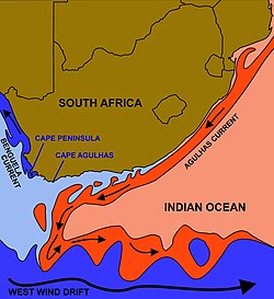
In contrast, the eastern coastline on the Indian Ocean is lush, well watered and warmed by the Mozambique Current; patches of Southern Africa mangroves grow along this coast.
The Cape Peninsula and surrounds have a Mediterranean climate, with cool, wet winters and warm, dry summers (becoming hotter in interior valleys).
The Cape Peninsula has a reputation for its wind: the dry "South-Easter" which blows almost incessantly in summer (December–February), and the "North-Wester" which accompanies the cold fronts that roll in from the Atlantic during winter (June–August).
The eastern section of the Karoo does not extend as far north as the western part, giving way to the flat landscape of the Free State, which – though still semi-arid – receives somewhat more rain.
North of the Vaal River the Highveld is better watered, with an annual rainfall of 760 mm (29.9 in) and a high altitude (around 1,750 m (5,741 ft)) which mitigates the extremes of heat of an inland area at this latitude.
Climate change in South Africa is expected to bring considerable warming and drying to much of this already semi-arid region, with greater frequency and intensity of extreme weather events such as heatwaves, flooding and drought.
In the Port Elizabeth region, national NGO Living Lands had in cooperation with an agricultural insurance company, planted 3.7 million trees as of late 2015, in order to restore the water catchment system and halt erosion.
[18] South Africa has lost a large area of natural habitat in the last four decades, primarily due to overpopulation, sprawling development patterns and deforestation during the 19th century.
South Africa is one of the worst affected countries in the world when it comes to invasion by alien species with many (e.g. black wattle, Port Jackson willow, Hakea, Lantana and Jacaranda) posing a significant threat to the native biodiversity and the already scarce water resources.