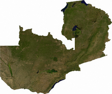
Geography of Zambia
There is a rainy season that runs from October/November to March/April.The terrain of Zambia is mostly high plateau, with some hills and mountains.
Zambia is a landlocked country bordered along Zimbabwe in the south divided by Victoria Falls, Congo DR in the north, Tanzania on the northeast, Malawi on the east and Mozambique on the southeast.
The level of land falls from the upper Congo towards the Zambezi depression in the South forming a plateau.
Current issues for the environment in the country include: air pollution and resulting acid rain in the mineral extraction and refining region; chemical runoff into watersheds; poaching, which seriously threatens: rhinoceros, elephant, antelope, and large cat populations; deforestation; soil erosion; desertification and lack of adequate water treatment, which presents human health risks.
[5] Zambia is party to the following international agreements: Biodiversity, Climate Change, Desertification, Endangered Species, Hazardous Wastes, Law of the Sea, Nuclear Test Ban, Ozone Layer Protection and Wetlands.