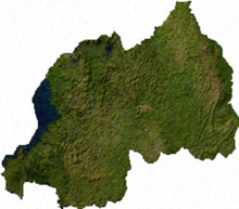
Geography of Rwanda
[3][4] The entire country is at a high altitude: the lowest point is the Rusizi River at 950 metres (3,117 ft) above sea level.
[3] Rwanda is located in Central/Eastern Africa, and is bordered by the Democratic Republic of the Congo to the west, Uganda to the north, Tanzania to the east, and Burundi to the south.
[13] This western section of Rwanda, which lies within the Albertine Rift montane forests ecoregion,[12] has an elevation of 1,500 to 2,500 metres (4,921 to 8,202 ft).
[14] The centre of the country is predominantly rolling hills, while the eastern border region consists of savanna, plains and swamps.
[15] Rwanda has a temperate tropical highland climate, with lower temperatures than are typical for equatorial countries due to its high elevation.
Natural hazards in Rwanda include periodic droughts and the volcanic activity of the Virunga Mountains, located in the northwest of the country, along the border with the Democratic Republic of the Congo.
Current issues concerning the environment in Rwanda include: the result of uncontrolled deforestation for fuel, overgrazing, soil exhaustion.