Geography of Tunisia
Most of this greater gulf forms the main coast of Libya including the city of Sirte which shares its root name.
The principal and reliable rivers rise in the north of the country with a few notable exceptions from north-east Algeria and flow through the northern plain where sufficient rainfall supports diverse plant cover and irrigated agriculture.
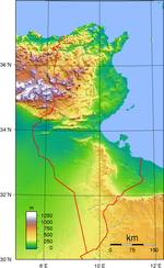
The Dorsal, the eastern extension of the Saharan Atlas Mountains, runs across Tunisia in a northeasterly direction from the Algerian border in the west to the Cape Bon peninsula in the east.
North of the Dorsal is the Tell, a region characterized by low, rolling hills and plains, again an extension of mountains to the west in Algeria.
In the Khroumerie, the northwestern corner of the Tunisian Tell, elevations reach 1,050 meters (3,440 feet) and snow occurs in winter.
The Sahel, a broadening coastal plain along Tunisia's eastern Mediterranean coast, is among the world's premier areas of olive cultivation.
A series of salt lakes, known as chottzz or shatts, lie in an east–west line at the northern edge of the Sahara Desert, extending from the Gulf of Gabes into Algeria.
The southernmost part receives rainfall as low as 50 mm (2.0 in) in areas around El Borma, along the Algerian border.
Tunisia possesses petroleum, phosphates, iron ore, lead, zinc, salt, gold and arable land.
Current environmental issues for Tunisia include: Tunisia is a party to the following international agreements: Biodiversity, Climate Change, Climate Change-Kyoto Protocol, Desertification, Endangered Species, Environmental Modification, Hazardous Wastes, Law of the Sea, Marine Dumping, Ozone Layer Protection, Ship Pollution (MARPOL 73/78) and Wetlands.