Geologic modelling
A geomodel is the numerical equivalent of a three-dimensional geological map complemented by a description of physical quantities in the domain of interest.
[1] Geomodelling is related to the concept of Shared Earth Model;[2] which is a multidisciplinary, interoperable and updatable knowledge base about the subsurface.
For example, in the oil and gas industry, realistic geologic models are required as input to reservoir simulator programs, which predict the behavior of the rocks under various hydrocarbon recovery scenarios.
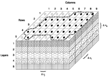
For the purpose of property or fluid modelling these volumes can be separated further into an array of cells, often referred to as voxels (volumetric elements).
Geomodelling generally involves the following steps:[3] Incorporating the spatial positions of the major formation boundaries, including the effects of faulting, folding, and erosion (unconformities).
Maximum cell dimensions are dictated by the minimum sizes of the features to be resolved (everyday example: On a digital map of a city, the location of a city park might be adequately resolved by one big green pixel, but to define the locations of the basketball court, the baseball field, and the pool, much smaller pixels – higher resolution – need to be used).
The preferred methods for calculating hydrocarbon saturations in a geologic model incorporate an estimate of pore throat size, the densities of the fluids, and the height of the cell above the water contact, since these factors exert the strongest influence on capillary action, which ultimately controls fluid saturations.
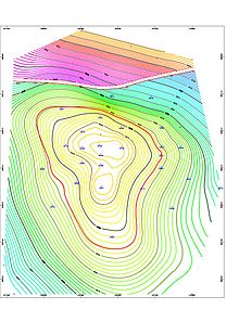
To reproduce more realistic spatial variability and help assess spatial uncertainty between data, geostatistical simulation based on variograms, training images, or parametric geological objects is often used, e.g.[5] Geologists involved in mining and mineral exploration use geologic modelling to determine the geometry and placement of mineral deposits in the subsurface of the earth.