Hurricane Cindy (2005)
The third named storm of the 2005 Atlantic hurricane season, Cindy developed from a tropical wave on July 3, off the east coast of Mexico's Yucatán Peninsula.
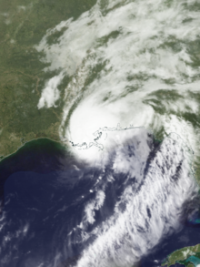
Cindy tracked toward the northern Gulf Coast and strengthened to reach maximum sustained winds of 75 mph (120 km/h), making it a Category 1 on the Saffir–Simpson scale.
The hurricane struck near Grand Isle, Louisiana, on July 5 at peak intensity, but weakened by the time it made a second landfall along southern Mississippi.
Cindy weakened over the southeastern United States and transitioned into an extratropical cyclone as it merged with a cold front on July 7.
Along its path, Cindy produced heavy rainfall, causing flooding and contributing to six traffic deaths – one in Alabama, two in Georgia, and three in Maryland.
The hurricane's damage was estimated at US$320 million,[nb 1] and was significant enough for five Louisiana parishes to be declared federal disaster areas.
Along the Gulf Coast, Cindy produced high tides, causing beach erosion and flooding that closed some roads.
[1] The wave continued westward across the Caribbean and was first included in the Tropical Weather Outlook (TWO) by the National Hurricane Center (NHC) on June 30.
[5] Late on July 3, the system developed into Tropical Depression Three about 80 mi (130 km) east of Mexico's Yucatán Peninsula.
[1] Due to an anticipated reduction in wind shear, the NHC forecast that Cindy would intensify to an estimated peak intensity of 50 mph (85 km/h).
Operationally, the NHC assessed it as a strong tropical storm when Cindy moved ashore, although the agency upgraded it after the season due to a reanalysis of radar-derived winds.
The hurricane weakened to tropical storm status over land, and at 09:00 UTC that day, Cindy made its final landfall near Waveland, Mississippi, with 50 mph (85 km/h) winds.
The remnants continued northeastward across the southeastern United States, emerging into the western Atlantic on July 8 off the mid-Atlantic coast.
The NHC later issued tropical storm warnings for the northern Gulf Coast between Intracoastal City, Louisiana, and Destin, Florida.
[12] In New Orleans, both the Louis Armstrong International Airport and Amtrak temporarily suspended regular air and train service, respectively.
[17] Across the southeastern United States, Cindy's strong winds knocked down trees and power lines, affecting about 278,000 people across New Orleans, as well as 35,000 residences in Alabama and 7,000 in both Florida and Mississippi.
[17] Across southeastern Louisiana, Cindy left at least $50 million in damage, mostly related to its winds knocking down trees and power lines.
[26] A strong band of thunderstorms moved into western Georgia, producing flash floods across six counties that swelled creeks and washed out a few roads.
[42] In northern Delaware, heavy rainfall and 30 mph (48 km/h) wind gusts knocked down trees, leaving about 100 homes without power.
[43] In Pennsylvania, rains from the storm generated flash floods in Lebanon and Lancaster counties, leading to water rescues after drivers were stranded in floodwaters.
[46] The combination of rains and gusty winds knocked down trees as far north as Franklin County, New York, some of which caused roofing damage.
[47] Near Montpelier, Vermont, the Edward F. Knapp State Airport set a daily rainfall record on July 9 when it received 2.15 in (55 mm) of precipitation.
[1] Most of the tornadoes occurred early on July 6, when the storm was weakening inland and starting to experience wind shear from an approaching trough.
At 01:45 UTC on July 7,[nb 2] a large tornado touched down at the Atlanta Motor Speedway in Hampton in Henry County.
Nearby, the tornado destroyed a gas station and shattered many windows of a nine-story condominium, as well as damaging the structure's roof.
The tornado was on the ground for 19 minutes, which immediately brought its path over Tara Field, where it heavily damaged eleven planes and five vintage helicopters, as well as two hangars.
In South Carolina, a waterspout developed over Lake Hartwell, which damaged docks and about a dozen sailboats, one of which was thrown 100 yd (91 m).
[nb 5][69] Cindy was the first of six hurricanes in 2005 to produce hurricane-force winds in the country, including Dennis a few weeks later, and Katrina in August.
[23] In five parishes, storm damage was significant enough for President George W. Bush to declare a federal state of emergency on August 23, which allocated money for public assistance and debris removal.
[73] During this time, the NHC designated another tropical depression that would later become Hurricane Katrina, which struck southeastern Louisiana on August 29 and severely damaged the same areas affected by Cindy.

Tropical storm (39–73 mph, 63–118 km/h)
Category 1 (74–95 mph, 119–153 km/h)
Category 2 (96–110 mph, 154–177 km/h)
Category 3 (111–129 mph, 178–208 km/h)
Category 4 (130–156 mph, 209–251 km/h)
Category 5 (≥157 mph, ≥252 km/h)
Unknown