Hurricane Hugo
Between September 17 and 21, Hugo made landfall on Guadeloupe, Saint Croix, Puerto Rico, and lastly South Carolina, with major hurricane strength winds.
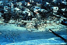
In the mainland United States, coastal South Carolina was hit by record setting storm surge heights, reaching 20.2 ft (6.2 m) near McClellanville.
The presence of another area of low-pressure north of Puerto Rico produced a gap in the Azores High, causing Hugo to then gradually turn towards the west-northwest with its forward speed decelerating.
[7] At 18:00 UTC on September 15, the first aircraft reconnaissance mission to probe Hugo reported that it had intensified to a Category 5 hurricane with maximum sustained winds of 160 mph (260 km/h) and a minimum central barometric pressure of 918 mbar (27.11 inHg), which turned out to be its peak intensity.
[7] Still several hundred miles east of the Leeward Islands at the time, this made Hugo the easternmost Category 5 hurricane on record in the Atlantic.
[7] Hugo's encounter with Puerto Rico weakened the storm substantially, its eye became ill-defined in satellite imagery and its winds had diminished to around 105 mph (165 km/h) by 06:00 UTC on September 19.
[7][9] By this juncture, the broader weather patterns that steered Hugo had changed: the Azores High became a dominant influence north of the hurricane and an upper-level low emerged over Georgia.
[7][9] The next day, it transitioned into an extratropical storm near Erie, Pennsylvania, and continued across eastern Canada, eventually moving into the far northern Atlantic where it was last noted on September 25.
The plane climbed to an altitude of 7,200 ft (2,200 m) before departing the eye via the northeast eyewall and returning to Grantley Adams International Airport in Barbados.
[15] The first hurricane watch was issued by the NHC at 09:00 UTC on September 15, covering much of the Lesser Antilles from Saint Lucia northward to the British Virgin Islands.
As Hugo tracked northwest across the Sargasso Sea between September 19 and 20, tropical storm warnings were issued for coastal areas of the Dominican Republic and The Bahamas.
[7] Barbados served as a staging area for disaster response in the Caribbean due to its strategic position in the region and distance away from Hugo's forecast impacts.
[18] Disaster preparedness plans were set into motion by Martinique's government ministries, dispatching crews to board windows and secure buildings.
[30] After Hugo departed the Caribbean, officials in South Florida convened on September 18 to discuss emergency preparedness plans, and some residents began to gather supplies.
[35]: A7 Carroll A. Campbell Jr., the Governor of South Carolina, issued a voluntary evacuation order before the coast was placed under a hurricane warning,[25] with the initial directive intended for barrier islands, beaches, and peninsulas outside Charleston.
[37]: 14 Civil authorities in Glynn County, Georgia, urged the 15,000 residents along barrier islands to begin evacuating on the morning of September 21 ahead of hurricane warnings.
This estimate was derived from an aircraft reconnaissance flight into the storm shortly before landfall; no weather stations were positioned along Bulls Bay, where Hugo's strongest winds likely occurred.
[59] The South Carolina Electric and Gas Company (SCE&G) called Hugo "the single greatest natural disaster ever to strike the state", inflicting $5.9 billion in property damage.
[71] The storm surge accumulated within the Ashley, Cooper, and Santee rivers, forcing them over their banks and submerging low-lying areas 10 mi (16 km) upstream.
Devastated groves of pine trees were characteristic of the hurricane's impacts, in addition to numerous unroofed homes and cotton crops injured by the winds and rain.
[84] Three beach communities in Brunswick County, North Carolina, incurred a total of $55 million in damage;[86] with at least 25 beachfront homes battered by the storm;[2] another 100 structures were threatened by coastal erosion.
[2] Hugo produced a nearly 50-mile-wide (80-kilometer) corridor of downed trees and power lines west of Charlotte,[59] and hurricane-force wind gusts extended 200 mi (320 km) inland.
[68] Widespread flash flooding occurred across eastern Tennessee, forcing the evacuation of people from affected areas; some of the evacuees had fled South Carolina for the Great Smoky Mountains.
[26] Military aircraft delivered 50 tons (45 tonnes) of supplies and over 500 emergency workers to Guadeloupe, along with Minister of Overseas France Louis Le Pensec;[29]: 4A 3,000 soldiers also accompanied the transport.
[41] The Federal Emergency Management Agency (FEMA) dispatched a C-141 airlifter with government relief workers and communications equipment to Saint Croix.
[108]: A6 However, local law enforcement in Saint Croix was unable to stop widespread looting, with armed gangs reportedly taking root the streets of Christiansted.
Residents of Puerto Rico's northeastern coast were encouraged to boil water to curtail the spread of food- and waterborne diseases, though power outages prevented most from doing so.
Churches and other private non-profit groups managed replacement housing for Hugo victims in at least four South Carolina counties whose governments lacked such capabilities.
[127][128] Extensive defoliation was documented in the forests of Dominica, Guadeloupe, Montserrat, and Puerto Rico, where vegetation was stripped bare of their flowers, fruits, and leaves.
Nekton communities suffered increased mortality in river channels and marsh creeks near the Charleston harbor due to hypoxia and lowered salinity in the water, though their populations recovered within two months.

Tropical storm (39–73 mph, 63–118 km/h)
Category 1 (74–95 mph, 119–153 km/h)
Category 2 (96–110 mph, 154–177 km/h)
Category 3 (111–129 mph, 178–208 km/h)
Category 4 (130–156 mph, 209–251 km/h)
Category 5 (≥157 mph, ≥252 km/h)
Unknown