Hurricane Kenna
Moving into an area of favorable upper-level conditions and warm sea surface temperatures, Kenna quickly strengthened to reach peak winds of 165 mph (270 km/h) as a Category 5 hurricane, on October 25, while located about 255 mi (410 km) southwest of Puerto Vallarta, Jalisco.
The worst of the hurricane's effects occurred between San Blas in Nayarit and Puerto Vallarta in Jalisco, where over 100 people were injured and thousands of homes and businesses were damaged or destroyed.
Early on October 22, the system developed into Tropical Depression Fourteen-E while located about 375 mi (604 km) south of Manzanillo, Colima.
Computer models predicted an increase in wind shear by 60 hours; as such the National Hurricane Center forecast the depression to strengthen to a peak strength of 45 mph (72 km/h) before weakening.
[2] The depression quickly became better organized with a great increase in convection near the center, and six hours after forming it strengthened into Tropical Storm Kenna.
[3] The storm moved to the west-northwest around the periphery of a mid-level high-pressure system, and initially failed to strengthen further with much of its convection being associated with outer rainbands.
[1] Shortly after becoming a hurricane, Kenna began to rapidly intensify with a 17 mi (27 km) wide eye located within its well-defined central dense overcast.
After turning to the north and northeast in response to the flow ahead of a large mid to upper-level trough, Kenna attained peak winds of 165 mph (270 km/h) early on October 25 while located about 255 mi (410 km) southwest of Puerto Vallarta, the third Category 5 hurricane of the season.
[1] Officials ordered for the evacuation of 50,000 residents and fishermen along the southwest coast of Mexico, including 3,000 in the Islas Marías,[7] 10,000 near Mazatlán, and 15,000 near flood-prone areas.
[9] Officials took security measures in Los Cabos, Baja California Sur, where the Asia-Pacific Economic Cooperation was meeting during the passage of the hurricane.
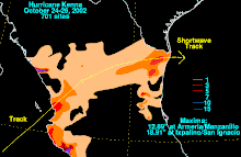
The hurricane dropped about 1.38 inches (35 mm) of precipitation while passing about 60 mi (97 km) east of the offshore archipelago, Islas Marías.
[1] The hurricane also produced heavy rainfall in Guerrero, Michoacán, Colima, and Jalisco, and hit Baja California Sur with strong winds and rough seas.
[8] Kenna destroyed the entire banana, tobacco, and tomato crops in the rural areas of San Blas, Tecuala, and Acaponeta, leaving more than 700 subsistence farmers and their families in need of water and food.
[20] In Puerto Vallarta, about 100 mi (160 km) southeast of the landfall location, the storm surge resulted in an estimated damage total of US$5 million, primarily to hotels.
[8] Immediately after the passage of the hurricane, the Mexican Red Cross prepared 180 technical staff and volunteers from seven states to deliver 125 MT of food, medicine, and clothes to the areas most affected.
Grupo Modelo, brewers of Corona beer, sent 6,600 gallons (25,000 liters) of drinking water and 1000 food sets for the San Blas area.

Tropical storm (39–73 mph, 63–118 km/h)
Category 1 (74–95 mph, 119–153 km/h)
Category 2 (96–110 mph, 154–177 km/h)
Category 3 (111–129 mph, 178–208 km/h)
Category 4 (130–156 mph, 209–251 km/h)
Category 5 (≥157 mph, ≥252 km/h)
Unknown