Hurricane Otis
On October 15, 2023, the National Hurricane Center (NHC) noted that an area of low pressure was expected to form several hundred miles south of southeastern Mexico over the next seven days.
[2] Accompanied by disorganized convection, organization into a tropical cyclone was deemed likely within five days as the system meandered in the same general area.
[2][9] Light to moderate southeasterly wind shear displaced convection northwest of Otis's surface circulation during the overnight hours of October 22–23.
The lack of vertical alignment and dry mid-level air delayed potential intensification despite an otherwise favorable environment consisting of high sea surface temperatures and abundant atmospheric moisture.
The high temperatures resulted from a combination of a record-warm September for Mexico, an ongoing El Niño, and the influence of global warming.
[11] A convective band developed halfway around the storm by the afternoon of October 23, and the surface circulation and thunderstorm activity moved closer together.
[12] During the overnight of October 23–24, the storm moved into a region of more favorable conditions, with higher sea surface temperatures and weaker vertical wind shear.
[2] Microwave satellite imagery depicted a low-level ring structure, often a precursor to rapid intensification, despite the overall sheared appearance of the system.
[13] The storm's forward motion also increased during this time, potentially offsetting the negative impacts of southeasterly wind shear.
[2] As the morning of October 24 progressed, outflow continued to expand in all directions atop Otis and many banding features circulated the storm.
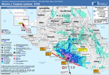
By 05:45 UTC (12:45 a.m. CDT), Isla de La Roqueta [es] entered the hurricane's eyewall and the storm's core made landfall just west of Acapulco around 06:45 UTC (1:45 a.m. CDT) just below peak intensity, though still at Category 5 intensity, with winds of 160 mph (260 km/h) and a minimum central pressure of 929 mb (27.43 inHg).
[21] Utilizing statistical inland decay models, the NHC estimated Otis to have fallen below hurricane status by 18:00 UTC (1:00 p.m. CDT).
Meteorologists Jeff Masters and Bob Henson at Yale University called the underestimation "one of the biggest and most consequential forecast-model misses of recent years".
Numerical weather prediction models failed to capture the magnitude of explosive intensification that occurred, in part due to a dearth of data.
Forecasters John Cangialosi and Lisa Bucci noted that many models showed the storm outright dissipating within five days.
[8] Early on October 23, Blake noted that models were incorrectly diagnosing conditions and showing Otis intertwined with the Intertropical Convergence Zone.
[11] Later that day, forecasters Cangialosi and Sandy Delgado noted a substantial disparity in various model solutions, with results differing based on how vertically aligned the storm would become or not become.
[31][17] At 09:00 UTC (4:00 a.m. CDT) on October 24, less than 24 hours before landfall, the NHC expected Otis to intensify into a Category 1 hurricane as it moved ashore.
[34] As the storm approached land and intensified further, a hurricane warning was issued for the Guerrero coastline between Punta Maldonado and Zihuatanejo at 09:00 UTC October 24, 21 hours before landfall.
[35] In response to the approach of Hurricane Otis, the Guerrero state government opened 396 shelters to accommodate residents displaced by the heavy wind and storm surge damage.
[44] A weather station on Isla de La Roqueta [es] offshore western Acapulco recorded a maximum wind gust of 135 mph (217 km/h) as the eyewall moved across the city.
[2] The storm surge was catastrophic near and east of the point of landfall, but a lack of tide station data prevented a quantitative estimate of the height.
[70] Additionally, the Pie de la Cuesta Air Force Base near Acapulco was damaged, which made it difficult for rescue operations.
[2] As of December 21, 2023[update], the official figures stand at 52 people killed and 32 missing,[1] with three foreigners included in the death toll[84] as well as at least two students attending the Autonomous University of Guerrero (AUG).
[88] Early media reports of an additional 16 fatalities following a power outage at a Mexican Social Security Institute hospital were denied by the government.
[89] Local officials told the Washington Post that they had counted 120 dead or missing, including 20 bodies that washed up onto Acapulco beach or by the docks, 10 bodies that were found floating in the ocean 16 kilometres (10 mi) west of Acapulco, two people who were missing from a vessel of three, and three people who died at sea on a four-person boat.
[93][94] The following day, municipal authorities dismissed the report as "speculation"[95] and, during a press conference, López Obrador reiterated that the official death toll remained at 48.
[111] However, the federal government rejected calls from the Chamber of Deputies to use oil surpluses, estimated to total up to 80 billion pesos, to fund additional recovery efforts.
[137] The Association of Banks of Mexico launched a payment deferral program that an estimated 300,000 individuals were eligible for, totaling 22 billion pesos.
[140] Widespread looting also occurred throughout the city after the storm,[141][142] prompting President López Obrador to deploy 14,700 members of the National Guard to erect checkpoints in response.

Tropical storm (39–73 mph, 63–118 km/h)
Category 1 (74–95 mph, 119–153 km/h)
Category 2 (96–110 mph, 154–177 km/h)
Category 3 (111–129 mph, 178–208 km/h)
Category 4 (130–156 mph, 209–251 km/h)
Category 5 (≥157 mph, ≥252 km/h)
Unknown


| Color key: | |
| Destroyed structures | |
| Damaged structures | |
| Possibly damaged structures | |